Part 1: Prelude, Trip Information and Practicalities
Part 4: Southern Scenic Route and Doubtful Sound
Part 6: The Ahuriri Valley and Lake Tekapo
Part 7: The Tranz Alpine Train and the West Coast
Part 8: Marlborough Sounds and Kaikoura (and Auckland Coda)
The Tranz Alpine Train
The Tranz Alpine train (https://railnewzealand.com/train-services/the-tranz-alpine) which runs from coast to coast across the South Island is one of the big tourist ‘must do’s’ of New Zealand. Naturally this means it is busy and a booking in advance is almost essential. The one-way trip is nearly five hours and you can do a there-and-back trip in one day but you only get an hour in Greymouth. In our case we took the trip east (Christchurch) to west (Greymouth) stopping for two nights in the heart of the Southern Alps at Arthur’s Pass. Arthur’s Pass is about half-way and the train offers day trip options there and back from Christchurch. It is a full-on tourist service with specially designed carriages with large wrap-around windows, an observation car open at the sides, a café on board and a premier service (Scenic Plus) that includes a lunch and tea. There is no doubt it is a wow-able trip, crossing plains and mountains and winding up river gorges, but if you detect a note of hesitation it is simply that we had taken the Bernina Express a year previously and, whilst that train had a similar internal layout, the scenery was just that bit more spectacular. I am nit-picking however. This is an almost unmissable trip if you are in the South Island.

Departure and arrival deserve a mention for practicalities. The station at Christchurch is a modern one away from the centre of the city (we taxied there with our luggage) and feels a little bit like the departure hall of a small airport. We arrived to find quite a queue waiting to have luggage checked-in, tagged and taken off to the baggage car. Several groups arrived in coaches to add to the sensation of airport check-in areas. Many folk are doing the trip one way and are picking up rental cars in Greymouth. The station at Greymouth was opened in 1876 and the building is heritage-listed and that makes it cramped when the train disgorges its load and arrivees cluster around the four or five car rental desks. You may have a bit of a wait to collect your car but there are some seats and a souvenir shop with refreshments available.
Mobility Access:
They do all they can to make this work for the mobility constrained. There is a slope as well as steps up to the Christchurch departure hall. Platforms are only a step down from the train and there are aids available if that cannot be managed. There are no seats in the open observation car. There are waiting rooms or areas with seats at all three stations that we used and that at Arthur’s Pass is heated, for which you are grateful on a grey, drizzly morning as you wait for a slightly delayed train.
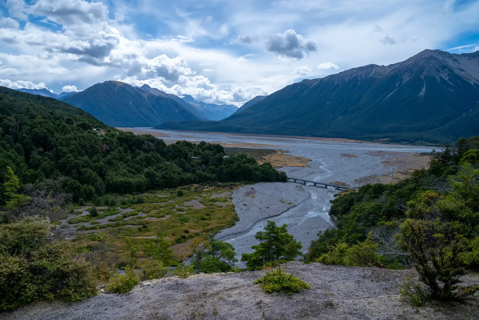
Arthur’s Pass (2 Nights)

The train station is at 737 metres (2,400 feet) in splendid isolation. Although there is a village here the population is around 50 people so it is tiny, but it is gloriously located in the ‘V’ of the Bealey River valley with beech forests climbing up the steep slopes before the jagged ridge appears above the treeline. If you are staying in the area, I suspect you are a serious hiker or climber (in summer) or, as we are, headed for all-in accommodation. This is more scenery-land country with National Parks and other protected areas spread over a swathe of the Southern Alps. The isolation is real; a stunning mountain landscape where we see few people and where there is the strongest emphasis yet on protection of the natural environment.
Arthur’s Pass: Wilderness Lodge
https://www.wildernesslodge.co.nz/new-zealand/arthurs-pass-wilderness-lodge/
And engagement with the natural environmental is the core of the excellent Wilderness Lodge. As always fuller details on the backstory to the Lodge’s development can be read on the website but, for the guest, it translates into a place run, very hands on, by Michael and Hannah, the son and daughter-in-law of the founder family. They and a highly engaged staff all seem to have two or three roles that they swap at will. Each day you can sign up for separate guided activities that run from straightforward walks around the lodge to longer walks in the mountains combined with kayaking. The lodge is in that semi-rustic, slightly spare style that you can also see in some accommodation in National Parks in the United States. Built some way up the southern hillside on the edge of the forest, all the Lodge’s 24 bedrooms and the public areas, look out over a glorious view across the valley through huge picture windows. Four rooms are in a separate building set a short distance away from the main building. All the rooms have a balcony or verandah with seats. Given the location it is not surprising that dinner is planned with four courses on a no-choice basis but with a vegetarian option. You have the choice of sitting at either your own or a communal table. Breakfasts offer the usual spread of hot and cold items derived from the English heritage of most of the Pākehā (non-Māori). Lunch is available as are picnics for daytime activities. We came away wishing we had had longer than our two night stay.

Mobility Access:
Although there are gentle changes of level (e.g a slight slope down to the main bedroom wing, two or three steps down to the dining area from the reception/lounge area), the overall effect is one manageable level. The wing with the bedrooms has two levels and the upper level requires going up a flight of steps. We had a ground level room. There are some seats and a grassed area in front of the building where you can relax, but moving further away from the main buildings means slopes up and down and encountering rougher ground.
Arthur’s Pass: Activities
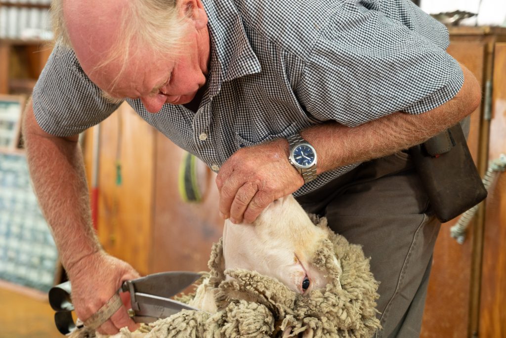
Sheep Farm Tour
This is the one everyone does. The farm is part of the land owned by the founders and the tour is run by Neil, the farm manager. Playing up to his own stereotype of the bluff Kiwi outdoorsman, he runs a highly entertaining walk down from the Lodge that encompasses sheep herding with dogs, engagement with super-cute orphan lambs and a display of hand shearing all laced with liberal doses of anecdote and dry humour. The whole tour takes about one-and-a-half hours or more.
Mobility Access:
It is a walk and you are on your feet the whole time when watching the sheep herding and shearing. However the team could not be more ready to find ways to do things for those who are mobility constrained. This was a good example. They offered one of the staff to drive us round in a pick-up rather than walk between the individual elements of the tour and provided a chair for sitting to watch.
Walks
My guide on one of the complimentary walks, Paddy, was also a freelancer for the Department of Conservation involved in a pest control project: tracking rat numbers in the adjacent forest to assess their population levels (this takes three years). He, like all the other staff, was a conservationist with a pragmatic streak but an engaging enthusiasm that turned the walk into a fascinating melange of geology, botany, ornithology and the politics of conservation. Our walk, it was just me, was the McKay Moa Forest Adventure that included standing in a braided river bed looking at tiny regrowth plants, a discussion of the use of 1080 poison as a pest control measure (for those interested try this for a fuller explanation – https://www.doc.govt.nz/1080-reassessment), travelling through time following the progression of new growth from thorny matagouri scrub to beech forest and a wealth of other fascinating insights.
The lodge has other marked, guided paths set out on laminated sheets kept inside the door to the gardens. One was a circular walk that took me around two hours (including stops to stare, photo and refuel) across the slopes of the hillside through scrub and forest with sudden views down cliffs to the gorge cut by a small tributary of the Waimakariri River.
Mobility Access:
These walks are non-starters for those with mobility limitations in walking. The ground is never less than uneven, often stony or rough and changes of height are frequent.
Kayaking
The lodge offers excursions that cost extra. I took this one, one morning with Jonathon (he popped up as receptionist and barman later in our stay). You get driven, in a suitably ancient minibus, up the valley to Lake Pearson (Moana Rua), a relatively small alpine lake and a wildlife refuge. No motorised boats are permitted so the lake is peaceful and, almost inevitably, in a stunning location. Jonathon does everything for me, unloading the kayaks and ensuring I am safely seated before guiding me around the lake for a couple of hours (with a break on the far side for coffee and biscuits) before seeing me safely grounded and out of the boat. The only human presence is two statuesque fishermen (and they are men). Jonathon is a great companion and, as well as imparting information about the birdlife and geology, our break-time conversation roves over high alpine growth, deer habits, Genghis Khan and James Cook, Māori uses of the waterside reeds and control of the introduced willow trees. It was a visual and intellectual pleasure. It may be obvious to say but, with the morning sun on the water, sun protection is a must to cope with reflected as well as direct sunlight.

Mobility Access:
If you can manage the paddling and with a strong enough back to be sat in a kayak for an hour or so then this excursion may be manageable. Your guide is on hand to help with the difficult bits (getting in and out of the kayaks whilst they sit on the lakeside gravel). Despite back issues I find I can manage this. It is certainly easier on the back in the touring kayaks used here (where you sit with lower body tucked inside the craft) than in (or rather on) the ‘sit-on-top’ kayaks, where getting decent back support is more difficult.
West Coast: Hokitika and Punakaiki
We only gave the West Coast one night (at Punakaiki) before heading north to Picton. This was, we know, being unfair to the West Coast but we had to make choices in our itinerary.
Hokitika
After The Tranz Alpine had dropped us in Greymouth around lunchtime and we had picked up the rental car, we had planned to head north to Punakaiki. We were diverted by our reading of The Luminaries (see Part 1) to visit Hokitika, about 35 minutes’ drive south of Greymouth. This now seaside town was the setting for the novel and its evocation of life in the New Zealand gold rush was one of the many excellent elements of the novel. It was a little difficult to envisage the then of 150 years earlier when visiting the now. We could not give the town much time to engage us, only sufficient to wander along part of the seafront, to sit for a short while eating a supermarket-bought snack whilst watching a local cricket match on Cass Square and, without success, to try finding the historic gaol building that featured heavily in the novel.
Pancake Rocks, Punakaiki (1 Night)
Then back to Greymouth and a further 45 minutes’ drive up the coast to the truly odd-looking geological formation of Pancake Rocks and our overnight stop. We were drawn here by those rocks but it also felt as if we had dropped into a land of lush, almost tropical vegetation. We knew that it rains far more on New Zealand’s West Coast but had not equated that with the outcome that we were now in a temperate rain forest climate. It made for another absorbing change in the scenery with ferns and big leaved plants clinging to the high cliffs that sit alongside SH 6 as it follows the shore. Pancake Rocks, and its associated settlement of Punakaiki, are squeezed between cliff and sea and are the centre for visiting Paparoa National Park, an area of rain forest offering yet more hiking for those so inclined. Clearly we are not, so it is to Pancake Rocks we go. It is impossible to describe this formation of smoothed, striated rocks worn by the sea into pillars, arches and folds. It is part of the National Park managed by the Department of Conservation (https://www.doc.govt.nz/parks-and-recreation/places-to-go/west-coast/places/paparoa-national-park/things-to-do/tracks/pancake-rocks-and-blowholes-walk/). There is a 1.1 kilometre tarmac path, smooth and properly finished, that circles through to the rocks through a shrubland of flax and ferns.
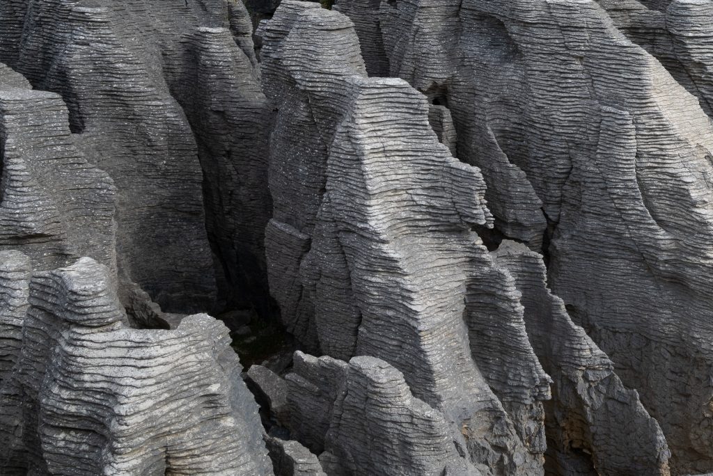
Apparently the time to go is high tide as, when the seas are not too still, you will see the blowholes in full spate. We did arrive then but the blowholes obviously require a rougher sea than when we were there. But our arrival at 17.30, when the Visitor Centre and attendant tourist shops were winding down and the daytime visitors had thinned to just a dozen or so, had an unanticipated benefit. With the car park nearly empty, the paths very quiet and the hint of the sun setting over a calm sea, the sheer oddity of the rocks was enhanced. There are a number of information boards beside the paths and also several curious wekas (https://www.doc.govt.nz/nature/native-animals/birds/birds-a-z/weka/) pecking around on and near the paths. The access to the paths is on the west side of SH 6 and the car park, visitor centre etc. are on the east side of the road with no controlled crossing point. The road is not busy, but it still felt a bit disconcerting.
Mobility Access:
The tarmac path is quite long but relatively flat and smooth with some viewpoints which have seats. The early part of the walk is through the fern woods and then past two-metre-high flax shrub, so you don’t see much but the plant life until you are a few hundred metres into the walk. Just go in with some awareness of the distances involved – it is worth it.
Punakaiki Hotel
Punakaiki, a settlement with little more than a few houses and some tourist accommodation to its name, sits 500 metres south of the Pancake Rocks. Set on a sandy beach, The Scenic Hotel (https://www.scenichotelgroup.co.nz/punakaiki/scenic-hotel-punakaiki/) is a modern hotel, designed as tourist accommodation, with the main building, including the restaurant, and most bedrooms on the beach side of the main road overlooking the sea. Other rooms, including ours, sit on the other side of the main road around 200 metres from the main building. I should say here that, although SH 6 is the main road north up the western coast, this is not a busy road at all. In common with so much of the South Island, the road seems very quiet, so safe crossing is not difficult. Our very large ground floor room, with its own terrace and a view of the ocean was light and furnished in a clean modern style. The staff we interacted with were all helpful. We had room service for our dinner and it wasn’t the best food we had had on our travels, although the view with the sky darkening as part of a classic sunset was another South Island special.

Mobility Access:
The main building has a set of outdoor steps (about 20) from the car arrival point to the reception and no lift we could use. This and the 200 metre walk to the main building was why we had room service, which is an offered (and efficient) amenity. A very personal viewpoint was that, whilst the room was good, we felt the hotel had a slight air of tourist functionality.
SH 6 to Picton
Yet another amazing South Island drive of around 370 kilometres (230 miles) through a kaleidoscope of different scenery. First the coast road was loomed over by cliffs that crowd the shoreline, their faces festooned with the bright greens of the temperate rain forest plants. Here the empty ocean-facing beaches appear then fall away at each rocky headland before a subtly different one repeats the pattern. Near Westport, the road turns inland and winds through the long stretch of the Buller Gorge carved through the northern (and lower) end of the Southern Alps. A brief encounter with the small river plain at Murchison and on up the river valley to the watershed. From here the mountains turn gradually to rolling hills and farmlands eventually flattening out into a massive riverine plain, awash with vines and hops, that is open to the sea on the northern coast of the South Island. Nelson, the South Island’s fourth city, provides an urban break in the journey, allowing us to entertain ourselves at the Beach Café and Bar in the Tahunanui Recreation Reserve, a once sandbar now reclaimed for a wide range of leisure businesses from a zoo through mini-golf and tennis to a skate park. Then onward again inland, cutting across the peninsula to Havelock, north of which the landscape becomes the water and island melange collectively known as Marlborough Sounds.
From Havelock the touted Queen Charlotte Drive winds along the bay-strewn coast to the town of Picton (https://www.newzealand.com/uk/feature/queen-charlotte-drive/). This drive has taken a pounding from adverse weather in the last couple of years (2022 and 2023). Storms and heavy rainfall have caused landslips that have left caries in this winding road reducing it to one lane in some places. In 2023 drivers only seemed to be protected from steep drops to the sea by temporary barriers. So take care. The drive, with the usual stops for stretches, photographs, petrol, sustenance and gawping, took a full day (about nine hours).