Part 1: Prelude, Trip Information and Practicalities
Part 4: Southern Scenic Route and Doubtful Sound
Part 6: The Ahuriri Valley and Lake Tekapo
Part 7: The Tranz Alpine Train and the West Coast
Part 8: Marlborough Sounds and Kaikoura (and Auckland Coda)
Dunedin to the Catlins
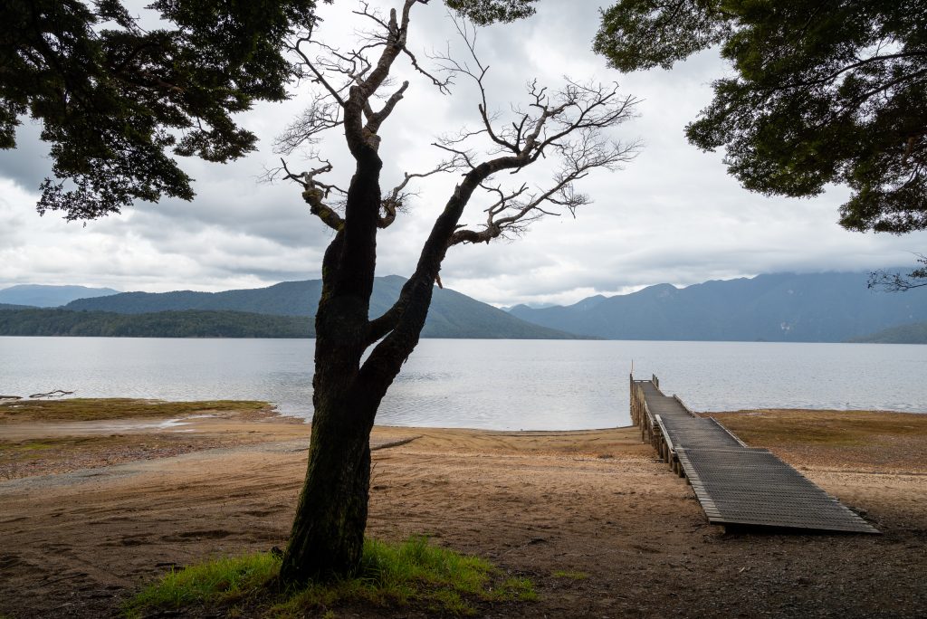
New Zealand has a number designated scenic routes and they each have their own websites with information on the route and activities and sights found along it. The Southern Scenic Route (https://southernscenicroute.co.nz) runs for 610 kilometres (380 miles) from Dunedin, broadly along the southern coast of the South Island and then cutting north up the eastern edge of Fiordland National Park to Te Anau and on to Queenstown.
The stretch between Dunedin and the heart of The Catlins is only 130 kilometres (80 miles). We ambled along it in the car for five hours, taking time to stop and take in scenery, wildlife and sustenance. First the coastal stretch with its glorious long white sand beaches to the mouth of the Taieri River, then inland to rejoin SH 1 and wend down to a caffeine stop at the ribbon town of Balclutha.
On the edge of The Catlins we diverted along a winding coast-hugging road, which provides views aplenty, towards Nugget Point, a sharp, vegetation-covered ridge ending in a dramatically-sited lighthouse. The road terminates at a small car park from where it is (according to web information) a ten-minute walk to the lighthouse. To us it looks as if you would need a machete-wielding mountain goat to negotiate a path that seems thick with chest-high vegetation growing along its up-and-down swoops and slopes, although the reality is not that bad. An easier option is the 60-metre packed gravel path that slopes up from the car park to Nugget Point Cliff View, so that is what we took. A splendid view of the lighthouse and you may see seals on the rocks below. There are some stopping points along the approach road that offer a view down to the beaches and which may also offer the chance to see the odd seal lolloping across the sand.
Mobility Access:
A trip to the lighthouse is a probable non-starter for those with mobility constraints given the nature of the packed gravel path. The path up to the Cliff View may be an easier option. The views from the road are still worth the drive.
Just beyond the town of Owaka is Catlins Lake, with spots to stop and picnic (as we did) and watch serene black swans on this peaceful spread of water.
The Catlins (2 nights): Driving Around
There is something very satisfying about Te Akau Tui Toka or The Catlins. It is, I think, the combination of forest, farmland and coastal seascapes in a relatively small area, about the same size as the United Kingdom’s Lake District National Park. The inland vegetation and landscape struck me as a mix between the green hills and valleys of Western Scotland and the dry, brown interior landscapes of Spain to which you then added a varied coast of cliffs, beaches and estuaries. There are destination places but, for us the primary satisfaction lay in ambling around in the car, stopping frequently just to enjoy the scenery. The towns and villages are small and have a neatness without any sense of homogeneity.
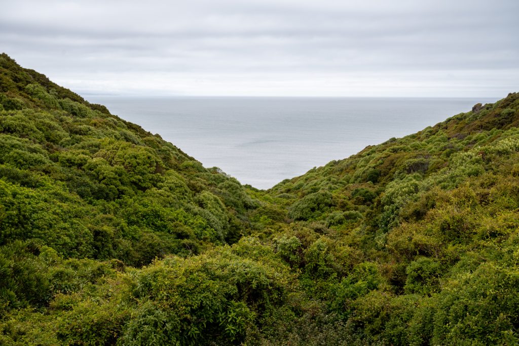
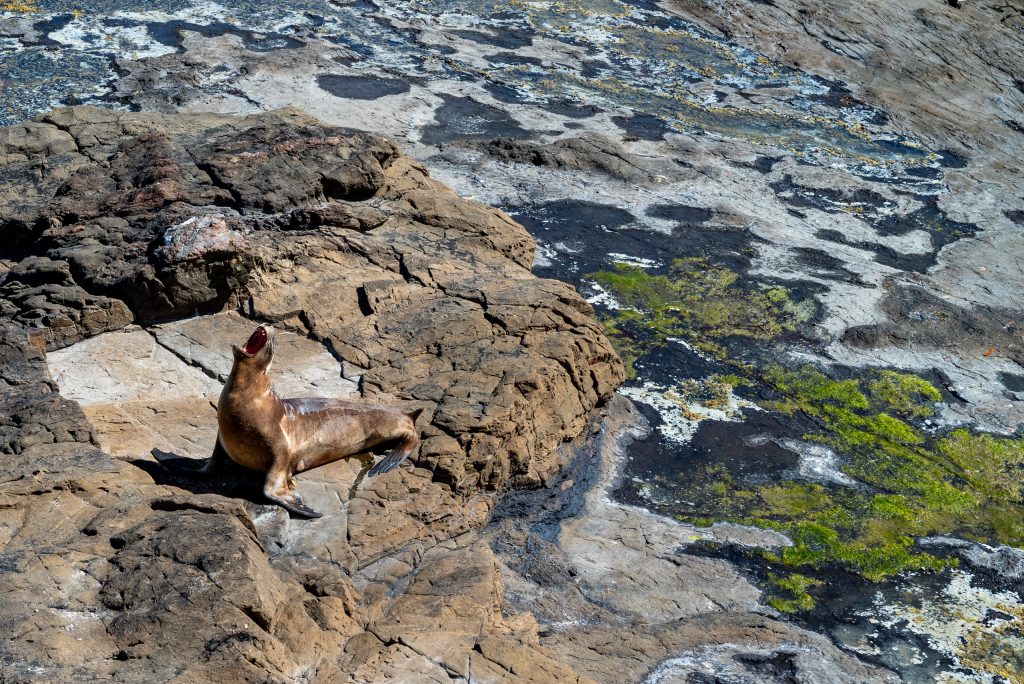
Based in the rolling farmland and forest near Pūrākaunui Falls, we simply used our one day to drive westward through forest and along coast to the open estuary at Fortrose before circling back again ending with a kaleidoscope of visual memories: the overhead sweep of fern trees on the walk up to Pūrākaunui Falls, the stunning views across the coast from Florence Hill Lookout, Maclean Falls in a forest landscape straight out of Peter Jackson’s Lord of the Rings, a solitary sea lion on the empty curve of beach at Porpoise Bay, the estuary at Fortrose with the oystercatchers and the precise, dainty stilts foraging on the mudflats and the extraordinary petrified forest of fossilised tree remains on the rock shelf at Curio Bay. The last of these was enhanced for us by another sea lion settling itself for an afternoon’s basking in the sun on the rock shelf only a few metres below us.
Being a map person, I suggest getting hold of The Catlins Visitor Map that can be downloaded from the official website (https://www.catlins.org.nz). For non-map people the website is still a good starting point for working out where to go and what to see on your stay in this region. Another useful source of information is often the host at your accommodation. Most of the accommodation in this area is small-scale: inns, cottages, homestays and B&Bs. These are run by locals with a wealth of knowledge about the sights and the issues affecting the region.
When planning to visit coastal sites, it is critical to check the tides in some places. At high tide the fossils at Curio Bay are covered and a beach location like Cathedral Caves becomes inaccessible on foot.
Mobility Access:
When researching which sites to visit, do assess accessibility quite carefully. For example, Cathedral Caves is promoted as a highlight but the walk from the car park is thirty minutes along a track then down to and across the beach, a non-starter for those with limited walking capacity. The same is true of the forest paths adorned with ferns that lead to falls like Maclean and Pūrākaunui. These sometimes muddy, sometimes uneven paths scramble upwards for some distance from the car parks along streams, with steps etched out of the rock and earth often made slippery by water – worthwhile if you can manage it, especially if you go later in the day in the summer months when the light is still good and the daytime visitors have lessened or disappeared altogether.
Having said that, there is much that can be seen from the car and from roadside stopping places or by a short walk from a car park. Thus the petrified forest at Curio Bay is a walk of about 200 metres along a packed gravel path from the café and car parks of Tumu Toka CurioScape, but if you drive just a short distance west to a small car park on your left you can shorten your walk to just 60 metres. Both paths bring you to a viewing platform set on the low cliff top. To get down to the rock platform and a closer look at the fossilised trees you have to climb down a set of well-constructed wooden and steel steps (about 60 steps). We managed because there are two platforms built into the structure that offered opportunities for short breaks (no seats on the platforms). Once down, the rock platform offers plenty of places to sit, rest and look.
The Catlins: Accommodation
Greenwood Farmstay provided our homestay (http://www.greenwoodfarmstay.co.nz/). With only three rooms this homely, comfortable place, run by retired farming couple Alan and Helen-May, is ideal to use as a base. Their house sits on a slope surrounded by their farm, now run by some of their children, and they provide a substantial cooked breakfast, a wealth of advice and a short 40 minute tour of the farm which is an informative introduction to the way farming is carried out and the problems it faces in this part of the world. The spacious room and the lounges are all on one level and furnished in a style that harks back rather than forward. This is no criticism, simply a means of describing the sensibility of this cosy place. Eating is communal in the kitchen diner. The beds were only queen-sized but I can manage that, despite my height, for a shorter stay. Outside the house the land slopes gently away to open out a view across the landscape. There are places to sit out in the gardens and enjoy the peace and that view. The only neighbour is another farm across the fields and the road between almost the definition of a quiet country lane.
Essentially a B&B, dinner can be provided but you need to mention this when booking. A wise option, in my view, as there are limited alternatives in the area. I could only spot one restaurant within half-an-hour’s drive, in the town of Owaka. These welcoming B&Bs seem to be the backbone of Kiwi accommodation in the smaller towns and the rural areas and provide a nice contrast to more hotel-like places.
Mobility Access:
The house is all on one level, at least as far as guests are concerned. There are just one or two steps up into the house from the adjacent tarmac car-parking area and garden sitting areas. The house is on the hillside, so the garden slopes down to the road.
The Catlins: Getting Around
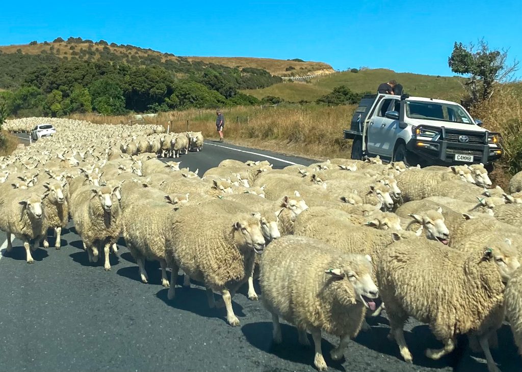
Perhaps it states the obvious to say you need a car. End of. Just beware unusual hazards. Not only unsealed gravel roads (covered in Practicalities: Car Rental and Driving in Part 1) but also sheep, lots of sheep.
Southern Scenic Route: The Catlins to Manapouri
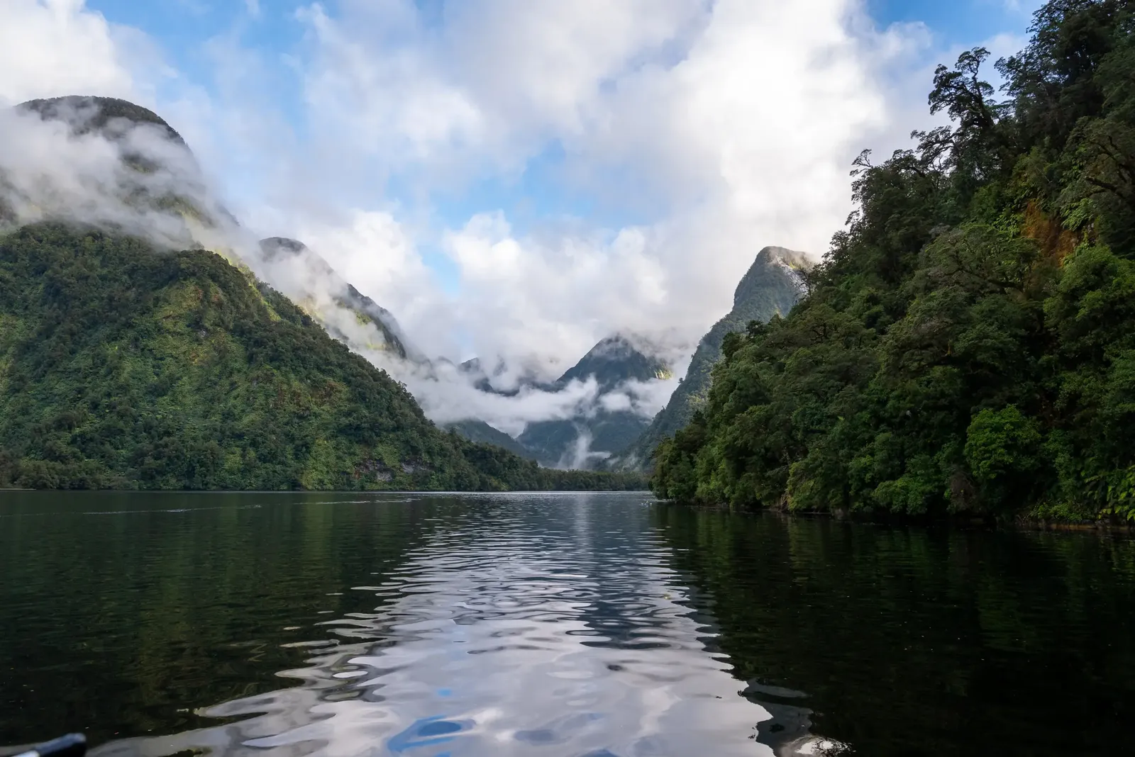
Back to this nationally designated route (https://southernscenicroute.co.nz) and this time a longer schlep of around 300 kilometres (186 miles). A day that started with an atmospheric mist over the hills cleared to a day of high cloud, our first sense of the rain that was to arrive in Manapouri on the east fringe of Fiordland National Park. Another day of dipping in and out of natural vistas peppered along the southern coast and north up the Waiau River which made the journey very enjoyable despite its length. We circled inland north of Invercargill, first hitting the coast at Riverton Rocks, a picture postcard fishing village, before stopping off at the broad sweep of surfing beach at Colac Bay, then on to the semi-abandoned fishing cove of Cosy Nook which, with the cloud closing in and the sea turning grey, hardly lived up to its name but was atmospheric all the same, next touching on the seemingly never-ending 27 kilometres (17 miles) of beach that faces Te Waewae at stopping points beside Monkey Island and Gemstones Beach and, once we had turned north and inland, turning west to Lake Hauroko. The last of these, which entailed a 30 kilometre (19 mile) out-and-back trip on a solid but unsealed forest road, was so atmospheric, the forest seeming almost primeval and the lake, New Zealand’s deepest, giving us a glorious first sight of the glacial lakes and fiords that predominate in this region. The looming beauty of the location was emphasised by the fact that there was no-one else there. Indeed, that we had seen few people at any of these lesser-known locations was only one factor that made a day of nine-hours travel from start to finish a particularly satisfying one.
Mobility Access:
Every location mentioned was sited next to, or below, a car park or lay-by alongside the road with clear sightlines of the land or seascapes.
Two honourable mentions for more of those excellent New Zealand cafés which we stopped at for caffeine and sustenance in small towns of no particular touristic note. The Country Cottage Café in a converted house adjacent to the main road and railway in the small junction town of Mataura (https://restaurantguru.com/Country-Cottage-Cafe-Mataura) and the more old-style food of the Well Café in Tuatapere (https://southlandnz.com/listing/the-well/1380/).
Manapouri (3 Nights)
In essence we had conceived of Manapouri as a convenient stopping place to allow us to undertake a boat trip on Doubtful Sound but the outstanding Cabot Lodge also provided a blissful destination in its own right. The intention had been to split our two nights at Cabot Lodge with the overnight boat tour on Doubtful Sound but, for reasons too complicated to recite, only I went on the boat trip. Our stay here did not involve any visits elsewhere, so this section focuses on the Lodge.
Cabot Lodge (https://www.cabotlodge.co.nz) was our first taste of a luxury lodge on the trip. It sits close to the saddle of a hill, a light-stone building built around a grassy courtyard with wow-inducing views from its four bedrooms and the public rooms. It is within the huge stock-farming station operated by the family that owns and built the lodge, which is run with consummate charm and skill by the son of the family, Brad Alexander, and his small team. Given the size of the lodge you would expect a personal service and that is what you get. Rooms are huge, the style is understated modern, the ever-changing menu and pre-dinner canapés of high quality. There are small terraces for sitting in the sun and a large lounge for preprandials with other guests. You can also feel comfortable there and in their library for those quiet times reading, writing and relaxing. Needing some gentle exercise, you can step through the garden gate and wander for short (or long) distances across the grassy meadows that fall away below the lodge. Dinner is part of the lodge package which, given the quality of the food and its location away from the limited offer in Manapouri, is no burden.

This was a private haven where we felt we could have spent more time just doing that relaxing thing in a cosseted environment.
Mobility Access:
Most of the lodge is on a flat, single level and, because the lodge is quite small nothing is too far from your room. Two of the rooms set at the back of the garden are on a higher terrace (because of the rising slope of the land) and require negotiating a set of fifteen external steps. Car is the only way to reach the lodge, as there is a winding, unsealed drive (just over a kilometre) that spirals up from the road. Car parking is at the upper level but there is a drop-off area at the lower level.
Both at Cabot Lodge and at Greenwood Farmstay we learnt a little of the world of stock farming in the South Island. Stock is cattle, sheep and deer (which explained the frequency with which venison appeared on New Zealand dining menus). We heard of the markets in China for antler velvet (https://www.nationalgeographic.com/culture/article/130130-deer-velvet-antler-spray-science-health-football-sports), controversial in some quarters; of post-pandemic labour shortages making it problematic to staff the critical slaughterhouses where the work is hard and the wages relatively meagre and the sheer hard work involved for many. Farm owners, like both the places we stayed, have supplemented the agricultural elements of their business with the touristic.
Doubtful Sound Boat Trip (1 Night)
First the link – https://www.doubtfulsound.com and the nature of the beast; a two deck, five sleeping cabin, 10 berth motor boat with a main cabin for dining, sitting, cooking with a wrap-around deck for fishing, launching their kayaks, helping land the lobsters and gawping at the stunning scenery and wildlife. A crew of two is on board with one as pilot/skipper/guide and the other as crewhand/chef/guide. Next the structure. You leave your chosen departure point on the first morning around 09.00 (the ferry dock at Manapouri in my case) and catch a ferry that zips you (and a hundred and more others on day trips) across Lake Manapouri in 40 minutes to a transit point at West Arm where everyone piles onto their land-based transport. Ours is a minibus for the nine of us who are on the trip and it wends slowly up an unsealed road through the forest, before emerging on the saddle of the Wilmot Pass at 671 metres (2,200 feet) above the sea level of Doubtful Sound. Here an astonishingly spectacular view down the Sound can be seen from the car park, where a short photo stop is taken. Back in the van you curl down through the forest, past the stoat traps fixed to some roadside trees, to the dock area at Deep Cove. There you board the boat which, with lunch being served, sets off out onto the water heading towards the Tasman Sea, 40 kilometres (25 miles) down the Sound. After a day’s sailing around, normally a suitable, sheltered spot is found for the boat to anchor for the night, dinner is had on board and in the early part of the next morning you spend more time sailing around before returning to Deep Cove around 09.30 for a return trip back over the pass and lake to reach Manapouri by lunchtime. Fishing from the boat and kayaking (using sit-on-top kayaks carried on the boat) are possibilities if you are interested. That is just the bare bones of a normal trip.
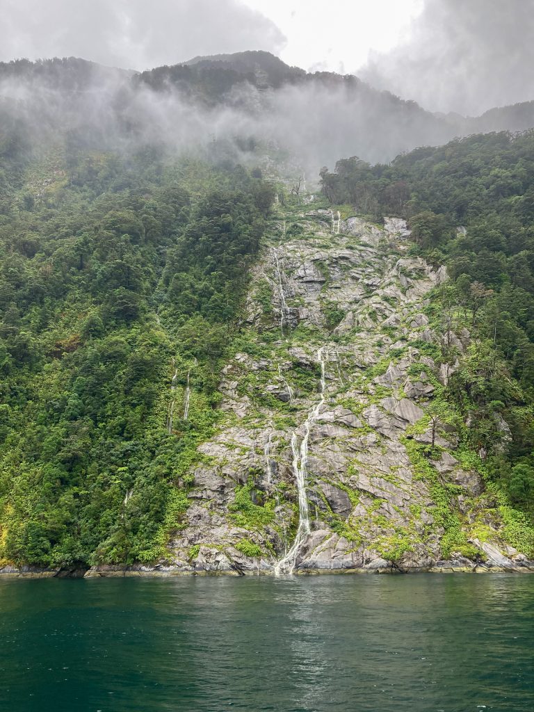
So much has been written about visiting the Sounds of Milford and Doubtful and all I can do is endorse the many, many people who have found this particular one to be an extraordinarily worthwhile trip. You will see seals and bottlenose dolphins. You will help the crew haul in the lobsters caught in the pots laid every day to provide part of the lunch that greets the next set of guests on arrival at the boat. You may see fish caught from the rods trailed off the back of the boat (a barracuda good for lobster bait on our trip). You can take one of the kayaks out for a spin when weather permits. Foremost you will just gawk at the scenery as the Sound unwinds, with forest seeming to defy gravity as it grips the vertiginous sides of the mountains that rise over 1,000 metres (over 3,200 feet) out of the water, marvelling at the changes wrought by rain that turns the trickles of water coming off the mountains into ferocious cataracts in the space of a few hours. You will meet the strange triangular areas of bare rock that are caused by what I called ‘treevalanches’, where, we were told, a single tree gives up the ghost of clinging to the rock and, in toppling over, creates a cascade downwards, ripping the rock bare of vegetation in a widening swathe. And on this trip, it matters not whether the weather is foul or fair because this utterly remote location is sublime and atmospheric in either or a mix of both. We had a first day with an umbrella of cloud obscuring the upper heights of the hills whilst squalling wind and rain that drenched everything was interspersed with dry spells. On the second day the cloud cover went higher and thinner, the skies blued and the wind fell to nothing. On that morning, sitting, unmoving, on a kayak in the middle of the flat calm water of Hall’s Arm was to give me a full sense of the sublime and of my physical insignificance.
A practical point. This is a BYO trip with no alcohol to buy on board or available at Manapouri dock. Some guests did not realise this, not having read the FAQs on the website, so if you want a drink make sure you buy yours before the day of the trip. I brought with me a bottle of red wine to go with the pork pot roast and to share with those who had brought none. White wine and beer can (normally) be kept chilled in the fridge on board.
Mobility Access:
For most of this trip, no problems are presented to those with mobility constraints. The access to, and egress from, the ferry at Manapouri and at West Arm is easy. The ferry has plenty of indoor and outdoor seating. The minibus is accessed right beside the dock. There are plenty of handholds and comfortable saloon seating on the boat. My minor caveats are that the access from the road at Deep Cove down to the boarding point of the boat is quite a steep slope on an uneven path that gets muddy when wet. There are handholds and it is only about 20 metres to the solidity of the dock. The other caveat is that access between the decks is only by a set of the steep ladder steps which you get on many smaller boats. It is the only way to reach your cabin and if you have difficulty with steep stairs, you should make careful enquiries of the team first. The passenger cabins are compact with low ceilings but, on these and on overnighting on the boat, I cannot make a meaningful report because this was not a normal trip.
So now I digress into the abnormalities of our sojourn. These add nothing by way of information to those considering the trip other than to demonstrate the lengths that the team is prepared to go to in order to ensure the trip is a success (and, for those on our trip, it was) despite those abnormalities. So for those with no wish for such a digression now is the time to pass on to Part 5 – Wānaka.
A Digression into the Abnormal
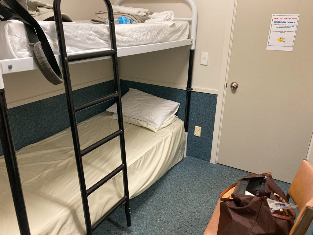
As we drove down to the dock our driver explained that he was carrying a part for the boat that would need to be fitted before we could depart but, at Deep Cove, we are met by the boat crew and, after a flurry of discussion between them and our driver, they emerge to explain that a vital component is kaput. It seems that the part brought over will not fit the need. The result is that the boat has only limited power (from its batteries). This means lighting will be non-existent, the oven and the fridge are unusable and, once the batteries expire, there will be no running water and the navigation system will cease to operate. Critically the toilets will be off limits. So, they explain, there are three options. We abandon the trip and return to Manapouri or we sleep on the boat with no lights and no toilets, but with access to the toilets in the hostel a 150 metre walk along a dark, gravel road from the boat, or we sleep in the hostel overnight. With the last two options the boat can still be taken out both today and tomorrow, with the batteries being recharged overnight. Given these options it is not surprising that an early group decision for the last option finds favour. There is some hopeful discussion that a helicopter can be flown in to meet us with the necessary engineer and part but, with the weather closing in, this becomes a non-starter. The ultimate result is that we are lucky, in the sense that the next few days tours will have to be cancelled to enable the repair to be undertaken. So off we go on our trip up the Sound returning to Deep Cove that evening to be introduced to our accommodation. Our ever-resourceful chef cooks up a pot roast dinner on the boat gas stove and so we are able to enjoy a full evening meal.
Now I must outline Deep Cove. It is no more than a small collection of functional buildings: two hostel buildings, a large workshop, and small exhibition space. The no-nonsense assistant warden has taken us through what we must expect in the hostel (as well as our small room there are ale and feale toilet and shower facilities along the short corridor). He also explains that, because we are on dry land, we have the opportunity to walk up into the forest after dark to see glow worms from the road and to flush out the elusive kiwi. To assist this he provides us with a Bluetooth speaker and mobile phone that has an app of bird calls. To see the glow worms we need darkness, so we have to kill time until total darkness falls, at this time of year around 22.00. It is an oddity of humanity that it is in these unusual situations that groups can come together more. Thus, as we make our own beds in the bunks of the hostel and prepare to hunker down in our cell-sized rooms with no more furniture than a double bunk and a single chair, an element of camaraderie develops in the group. We while away the time before darkness in the functional communal space of the hostel with its big kitchen area, two large dining tables and several armchairs in varying states of decrepitude. Our amazingly helpful chef has transported a whole series of supplies: tea, coffee, biscuits, games, milk, sugar, leftover wine, insect repellent and hair dryers into the communal space. Before darkness falls avian entertainment arrives in the form of a kea, a large native parrot, that ambles up the hostel steps. The warden has warned us that keas will steal anything that is not nailed down and with the things that are nailed down will try to rip them to shreds with their curved hook beaks. As our visitor wanders up the steps of the verandah area and stands around to be photographed while seeking a biscuit fed to it by one of us, you would think they pottered around everywhere. It is only later that I learn these birds are endangered and that the bird should not have been fed.
With darkness we head off up the road. The darkness is and must remain complete, as smartphone torches would throw too much light to allow the glow worms to be seen. We trudge and stumble up about 400 metres when pearlescent spots start to emerge gradually, like stars, as your eyes adjust to the light. They seem to be deeper into the undergrowth here, never on the roadside surface of the bush, as if wanting to draw you into the forest. Our glow worm viewing satiated, we endeavour to lure the kiwis out of the forest with the Bluetooth speaker but before we can give any real time to this the rain returns and we stumble back down the darkened path to bed.
It is strange how this kind of unexpected turn of events can actually enhance the experience of the trip rather than detract from it. It gave a focus to those on the trip to engage with each other as well as with the extraordinary land and seascapes around them.