Part 1: Prelude, Trip Information and Practicalities
Part 4: Southern Scenic Route and Doubtful Sound
Part 6: The Ahuriri Valley and Lake Tekapo
Part 7: The Tranz Alpine Train and the West Coast
Part 8: Marlborough Sounds and Kaikoura (and Auckland Coda)
The Ahuriri Valley and The Lindis (3 Nights)
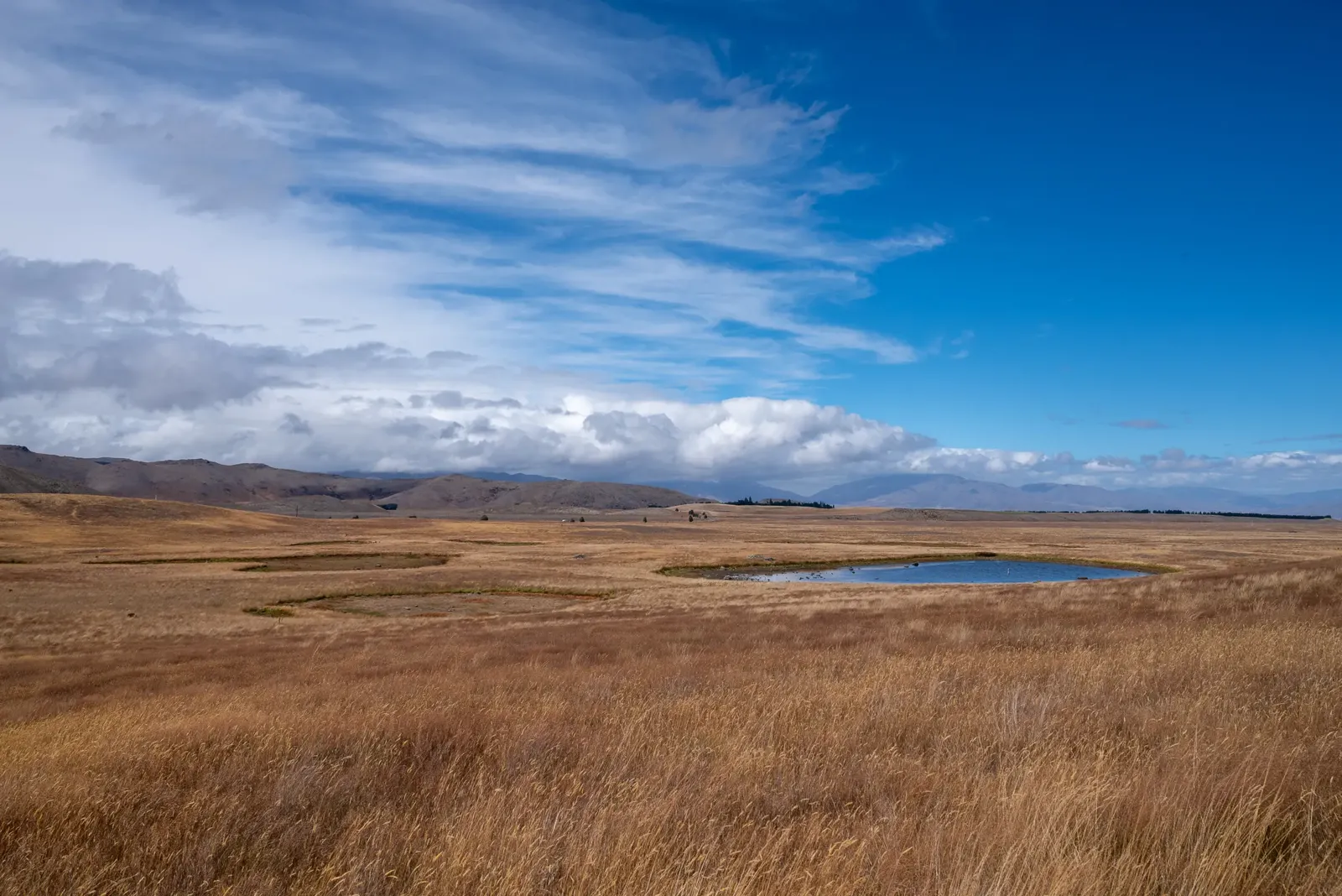
Northward over the Lindis Pass from Wānaka, this remote river valley cuts into the eastern fringe of the Southern Alps. It is a drive of only 110 kilometres (68 miles) but we are moving from a bustling urban space to a world where you can be overwhelmed by the natural landscape, where the sky is a roof of stars because there is only a smidgeon of light pollution. But here we are also in a place of pampered modern luxury, New Zealand style. For us the draw was The Lindis, a hotel that is in an extraordinary ultra-modern building set, all alone, in this dazzling valley (https://www.thelindisgroup.com/thelindis). It is the most expensive and luxurious stopping point on our trip so, because the whole of our stay revolves around the hotel and its activities, I have not divided this section into further subsections.
Seen from the low bluff above the hotel’s main building, it looks as if some alien has crashed a wooden flying saucer and left it embedded in the slope of the river valley. This is a piece of sculptural architecture, all curves, in natural materials. There are only five suites in this building and three luxury pods, a 100-200 metre walk away along track-style roads. Room may be the wrong word to use about the place where you head rests. Vast was the first word that came to mind to describe the open plan layout rooms where your bed sits. As well as the space itself, the beds are vast and the windows are vast, the latter giving onto a view north-west along a valley rimmed by snow-capped peaks – a landscape that epitomises the vastness. The staff are unfailingly helpful, the food excellent without being overwhelming. Access to the hotel is up an unsealed road off SH 8. This road runs for 15 kilometres (9 miles) before there appears on the right the strange sculpture like a set of rusting organ pipes, half-buried, that acts as a gate to the hotel. The hotel is hidden in folds of the land and you wind down to a small gravel drop off area beside the main building.

A stay is structured so you can partake of activities – as many and as few as you want. They run the gamut from the adrenaline-soaked to the most gentle: self-drive off-road buggies, heli-tours with meals in the mountains, horse riding, fly-fishing, hiking, e-biking and peaceful outdoor dinners and picnics. For much of the time we just savour the peace of the hotel. Reading or listening to music or podcasts, whilst sitting on the outdoor armchairs in the small paved area outside our room, or writing, sitting at a desk in the public space, both facing a stupendous valley view. It is a view that changes dramatically both with the passage of hours or with changes in the weather and would require paragraphs of description and several photographs to get close to doing it justice. So you will get no overkill here, as there are plenty of writings and images you can find online. Throughout the day the wide glacial valley and its meandering river hum with inactivity. You may see the occasional guest in waders trying their luck at landing trout at a bend in the river. A distant herd of Black Angus cattle graze in the farmed land of the valley floor. Very occasionally, far-off, a vehicle on the valley road unfurls a plume of dust into the air. Raptors float gently, circling on the up-draughts of the summer air. The only frenetic actions come from the swifts as they dart around the area outside the building in the late afternoon.
The road up the valley continues beyond the hotel for another 20 kilometres (12 miles) to its end; a patch of ground where serious hikers park, hoick their huge backpacks aboard and head up a series of tracks into the mountains. It was to this patch of ground that I ventured on my first (and so far only) e-bike ride. Bike, helmet, gloves, rucksack, binoculars, snack box, sun cream, insect repellent and water came from the hotel. I provided a dressed self and my camera. After a few pieces of guidance given on how to use the bike and a few test runs up and down part of the drive, I set off up the valley aiming for the parking patch. Four hours later and I am back at the hotel agonising for a cushioned seat that does not move. Acute scrotal discomfort apart, the other downside for a fair-skinned person was a total lack of shade on the trip. The road is a mish-mash of potholes, stream crossings, corrugations and long stretches where the only hazards are sliding on the gravel or being distracted by the scenery. At the car park patch there is a very weathered wooden table and bench where I can eat my sustenance and revel in being the only person in sight to take in the quiet of the valley and the cloud shadows moving swiftly across mountain slopes.

Our other main activity is one of the hotel’s Signature Experiences, a lunch-time picnic, so splendid that we dub it The Picnic. Manager Andy ferries us a short distance over the meadows behind the hotel, sets down tables and chairs, lays out a tablecloth and a cold feast, tells us the gentle breeze should be sufficient to ward off most bugs and leaves us to glorious isolation for two hours. For company we have the river at the bottom of a short cliff where natural erosion by the river has created a grand amphitheatre. Below us the geologic actions of the river have left the still surface of an ox-bow lake that draws a pair of black swans. Another different, but still wow-inducing, scenic location.
Mobility Access:
Within the hotel no problems at all because everything is on one level. There is a minor concern here in that any other activity, beyond the picnic, may not really manageable for those with mobility constraints (I am assuming bad backs and other conditions where jolting needs to be minimised would not take to the buggy or horse ride options). The hotel has several excellent marked walks you can follow but even the shortest one, over the hill behind the main building, requires walking on uneven tracks, across tussocky grassland and up and down slopes. There is nowhere around the hotel where short walks on smooth, flat ground can be taken to move stiff limbs. That said, the staff are eager to assist in every way to try and find workable options and the beauty of the place means taking in the sun, sky, stars and scenery is a joy of itself.
Lake Tekapo (3 Nights)
Another town whose services seem aimed principally at the tourist and which is located on the southern end of a glacial lake, but which has a different feel to sophisticated Wanaka. A small town (which means very small, with a population of under 600) that offers us a change from the cossetted luxury of The Lindis. Apart from its own scenic beauty, it is also our centre for a day trip to Mount Cook but, primarily, because it is at the heart of a Dark Sky Reserve of which more anon. One big draw for tourists is Instagram star, The Church of the Good Shepherd, a small stone chapel of no particular architectural or historic merit that seems to derive its selfie-ability from its location on a lakeshore promontory. The town is centred round a precinct of low buildings that contains the range of tourist and local services – eating places, takeaways, accommodation, souvenir shops, tour agencies, outdoor sports shops (complete with bike rental), bookstore and a small supermarket. From there the town spreads out on both sides of the Tekapo River with, mostly, single storey dwellings many, many of which are holiday rentals or B&Bs. We are staying in one of the latter.
SH 8 to Lake Tekapo
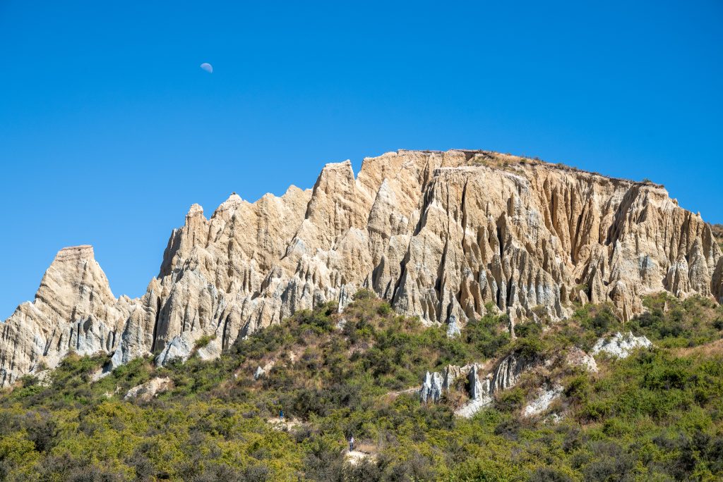
The road to Lake Tekapo was only a 120 kilometre (75 mile) drive from The Lindis but was punctuated by three, completely different, wow-inducing sights. The first was the clay cliffs near the town of Omarama. Heading north on SH 8, these bizarre clay rock formations are glimpsed off the west as you approach the town. Reaching the car park that serves the cliffs involves going through town and driving west then south west, the last section on an unsealed road that leads only to the car park. To me, cliffs are a bit of a misnomer for these strange formations look, but for their light brown clay colour, somewhat like stalagmites that have escaped their underground cave. From the car park a wide packed gravel path leads 400 metres up a gentle slope to the heart of the rock formations. There is an honesty box for paying for car parking on the road up to the cliffs.
Mobility Access:
The track from the car park may be too much for some and, once at the base of the cliffs, getting in amongst the pinnacles is more difficult as the ground becomes rougher and more uneven. That said you can actually see the formations very clearly from the car park and, even if you decide to go no further, you gain a real sense of their singularity.
Just south of Lake Pukaki , wow number two is actually prompted by a man-made structure. Heading across the plateau on one of those long straight stretches of road that are a feature of the plateau landscape of central Otago, SH 8 rises gently to a bridge across a canal. And this canal is no narrow winding waterway but an arrow-straight beast the width of the Manchester Ship Canal with an unworldly cerulean shade. What is it here for? There is no water traffic out here that could conceivably make use of such a behemoth. Power is the answer; hydro-electric power – https://www.meridianenergy.co.nz/power-stations/hydro/about-the-waitaki-hydro-scheme. There is a campground where SH 8 crosses the canal. Here you can pull off for a longer look. You can also find out more detail about the scheme from information boards beside the barrage in Lake Tekapo.
Mobility Access:
Just a view that can be seen from the car whether crossing the bridge or parked beside the canal.
Our final wow comes as we catch our first sight of the sun glistening on Lake Pukaki and it is a wow caused by a colour. This large glacial lake is a seemingly impossible turquoise blue. We screeched to a stop at the Punatahu Visitor Centre (and salmon shop), that sits in a car park area at the south end of the lake, to gaze in astonishment. Erosion of glacial silts held in suspension creates this almost unworldly colour. Beware the weather. As we discovered when we drove back around the lake en route to Mount Cook village a day or so later, the overcast skies had flattened the colour of the water back down to a more standard blue-grey-green.
Mobility Access:
Photographs can easily be taken from the lakeside car park and there are a couple of tables with bench seats alongside the parking area.
Lake Tekapo Activities
Mount Cook Village and Glacial Lagoon Tour
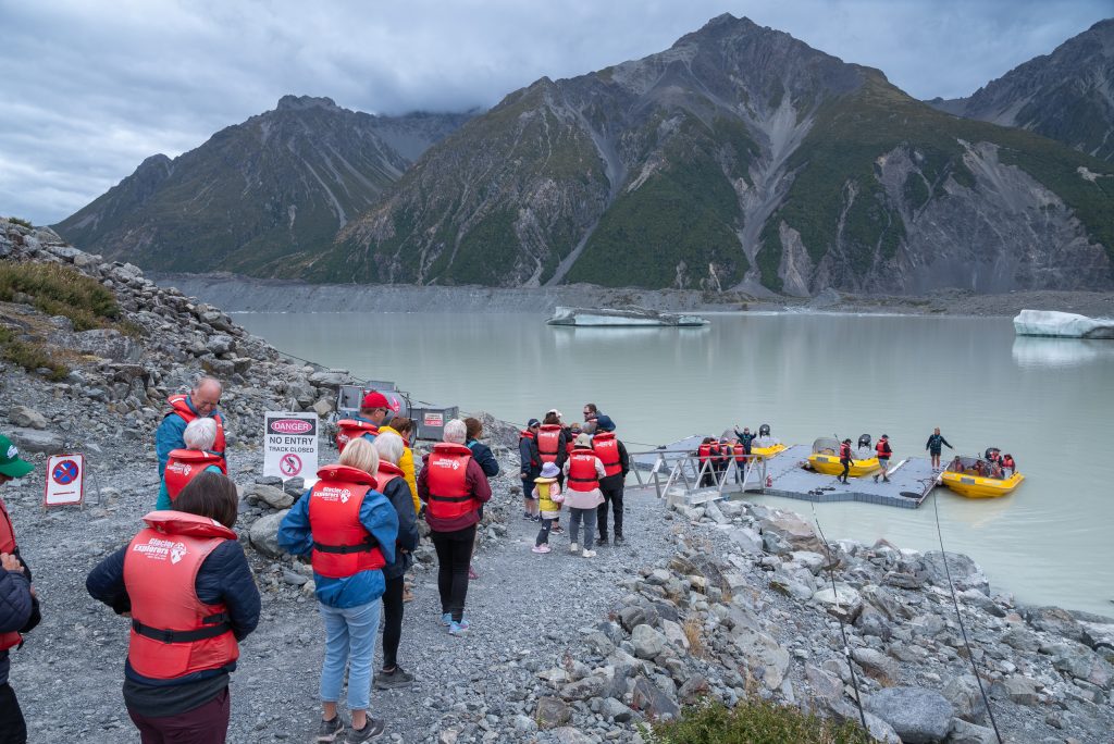
This glacial lagoon boat tour (https://www.hermitage.co.nz/experience/glacier-explorers/) was pre-booked by our travel advisers. The lagoon is a creature of the climate-affected Tasman Glacier and sits a short drive away from Mount Cook Village, de facto a centre for winter sports and summer hiking and mountaineering. The tour meets at the village’s main hotel, The Hermitage. Set higher up the mountain above the main part of the village, the hotel offers a café and restaurant and, in the foyer area, the Sir Edmund Hilary Museum. All of which means the non-touring guests can rest and take their ease whilst taking in the wow rated views of Mount Cook, the Hooker Valley and the fascinating glacial plain that spreads out from the towering mountains. Parts of the valley floor look more barren than I expected, brown and sandy. A later, closer sight shows what I thought was sand is actually brown plant life, a colder climate moss or some such.
The tour group (about 30 or so) are shipped in minibuses to a car park at the base of the terminal moraine. There is a 25 minute walk up and over the moraine on a rough track, quite steep in parts. Then, suitably briefed and life-jacketed, we are placed in Zodiacs, about 12 to a boat. These have rows of seats. An engaging guide/pilot keeps us informed and entertained for our time on the water stopping by small icebergs, photographing each of us holding a suitable chunk of ice and taking us as close to the glacier front as is safe (about 200 metres). We were on the water for about an hour. The weather was not the best, grey and overcast, and the stone materials in the ice gave the lake a dull, dirty mien. I have done other glacier lagoon tours and, despite the quality of the guides, I did not find this quite as atmospheric as those.
Mobility Access:
No, I am afraid, for those who struggle with uneven terrain and slopes. The walk from car park to jetty (and back) puts it out of reach for those with mobility constraints. Because the hotel is well up the mountainside it is not close to the rest of the village. The car can be used to drive around and take in the views and that odd brown moss.
Lake and Hill Walk
If you do an internet search for walks (not hikes) around Lake Tekapo two that you come up with are Cowans Hill and Pines Beach. By combining them I created a gentle extended walk for myself with a blissfully varied set of landscapes that took me about a leisurely three hours. Starting and finishing in the town precinct, I headed across the footbridge over the outlet from the lake of the Tekapo River where an uneven but manageable path curves round the lakeshore to Pines Beach with reeds, foreshore and herons foregrounding the lake. Then, cutting south across the disc golf course and climbing up through the pine forest, you can cross SH 8 into the open grassland beyond, where a marked track then path takes you up Cowans Hill. Although its summit is at 783 metres (2,360 feet) above sea level, it is only just over 60 metres (nearly 200 feet) above the level of the lake. It is a flat open high point, with 360° views and a resting place for a break, set in a vast swathe of glacial valley grassland that stretches away southwards. In that grassland several small kettle lakes act as stopping points for many migrating geese and ducks. The wind zips briskly over the plateau and the sunlit day is a joy, with encroaching rain clouds on the hills to the east adding to the spare beauty of the scene. The path heads west into a dry pine forest and scrubland tipping down to run along a cliff above the Tekapo River. Here the river is no more than a disconcerting trickle emanating from the barrage that takes SH 8, and me, back into the town precinct. I saw not another soul for most of the walk, giving me the thought that this was another of those unsung activities that really brought the quality of the South Island to the fore.

Mobility Access:
Clearly a non-starter. But from the town precinct and its shops and eating places, packed gravel paths and a grassy park give access to the lakeshore (a stony beach) after around 200 metres. Picnic tables and benches are dotted around this grass area with its view up the lake and across to the selfie-takers hustling around the Church of the Good Shepherd.
Dark Sky Project
As I recall the sight of the fast-moving International Space Station across a night sky plastered with stars and the fuzzy disc of the Milky Way as seen from the summit of Mt John, I find it difficult to resist the pun, but this really was the star of Lake Tekapo’s show. The town is at the heart of Aoraki Mackenzie International Dark Sky Reserve, an area protected from light pollution by strict regulation (https://darksky.org/places/aoraki-mackenzie-dark-sky-reserve/). I confess I had not heard of these reserves before and was surprised to find that the United Kingdom has several, including Snowdonia and the North York Moors. Here the overt attempts to minimise light pollution are of a different order to my awareness of light management in those places. For example, here the streetlights are only a metre high with specially designed caps to ensure light is not thrown upward. Key to the reserve’s importance is the University of Canterbury’s Mount John Observatory, set on top of the 1,000 metre (3,280 foot) knoll that sits alongside the town. The summit is open to walkers and tourists during the day (with a café open to the public during the mornings) then in the evening the roads up the hill close to allow the observatory operational time to view the night sky. But to garner funding and enthusiasm for the Reserve and for astronomy, each clear night the Dark Sky Project runs a tour up to the observatory from its modern centre (opened 2019) in the town precinct (https://www.darkskyproject.co.nz/choose-your-experience/the-summit-experience/). After gathering at that Dark Sky Project centre (complete with its own ‘experience’, shop and restaurant), the tour involves a ride in a small coach from the centre up to the summit. There you are met by a guide, in our case an amazingly enthusiastic and patient astronomer from the University, who talks you through the night sky, walks you round the secondary, older telescope and several other smaller telescopes all specially set up to allow you to see astonishing sights such as a spidery nebula, a dusty gas cloud and a nearby star that emerges as two separate stars. In order to maintain your night vision all light sources are forbidden. The coach driver douses his lights as we approach the summit, we are told firmly not to use smartphone torches, camera flash and screens. To help see our way around the uneven ground at the summit we are given fobs with red light beams to be shone only at the ground. I have seen clear night skies in other places but I have never felt so enveloped by the glory of the night sky.
It can get very cold on the summit at night and we were grateful for the extra-thick weather jackets that were on offer at the Dark Sky Project centre before we set off. Take one even in the summer months. And, obvious though it may seem, you need complete darkness for the tour. The practical point is that, in summer, the tour starts late in the evening. Ours, in mid-February, started at 22.00 and took over two hours.
Mobility Access:
You would think given the uneven ground at the summit and the 100 metre walk up a packed gravel slope from the car park to the observatory buildings that this would be impractical for the mobility constrained but if you can manage limited walking, perhaps with a supporting arm for the slope, the team at Dark Sky Project can make it work for you. There are a number of stops whilst features of the sky above are explained and wondered at and only short distances to cover in-between. For sitting during the explanatory stops and when viewing through the telescopes, the team provided a stool and chair, which they helpfully carted around for us. This made the whole experience so much more manageable.
Lake Tekapo Accommodation
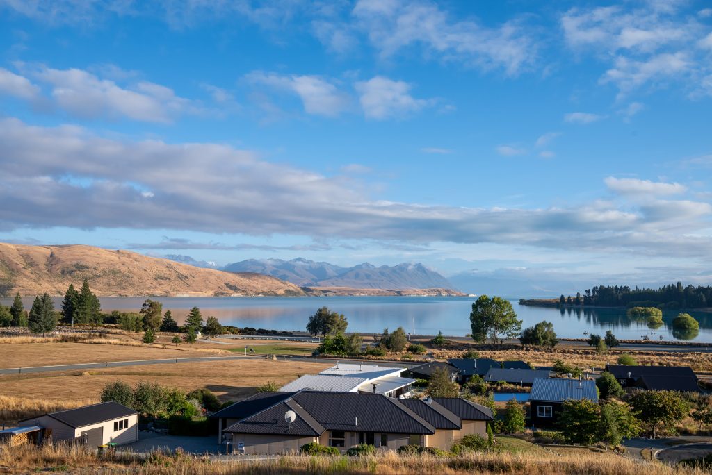
We are back to the world of B&B and a corker it was too. Ranginui (https://ranginui.nz) is set up the slope that rises from the lake as part of a neatly laid out estate of trim homes with well cared for gardens. Although on two levels, the rise in the slope means the bulk of the house is on the upper level, accessed from the road behind. The three guest rooms are on this level: neat, unfussy, modern with French doors that open onto a balcony and yet another stunning lake and mountain view. One was ours and came with king-size bed. Sharing the view, the central room was the dining area and lounge, on the other side of which is the kitchen and other living quarters of owners, Anne-Maree and Sab, who are excellent hosts. They served up information on local places and restaurants, anecdotes on their shared love of art and travel, the plates and cutlery to allow you to have your own food in the dining area and, very kindly, their washing machine and outdoor drying facilities. The breakfast is extensive and good, but Australasia novices should beware the little packs of jams, etc. A German couple opened a portion of what they thought was a chocolate spread, put it on their toast, took a bite and grimaced. It was, of course, Vegemite.
The highway is too distant to be disturbing and the only sound that came close to us was from the distant bleating of hundreds of sheep who were brought in one day to a set of pens in the park far down the slope for a big sales session. Sab had been out early on sales day helping friends transport and manage their flock into the sale pens. After dark a minor hazard can be found on the residential roads: rabbits. These come out by the score, sitting around the roadsides and on the roads unmoving until the last minute then, as you approach, some sort of kamikaze instinct sends them dashing off in any direction, including across the route of the car.
Mobility Access:
All rooms are on one level with the smooth paved car parking area outside the front door. The in-room showers are only an almost negligible step up in level. It is a 2.5 kilometre (1.5 mile) walk into the small town centre, so a car is a near necessity.
Lake Tekapo Food and Drink
Lake Tekapo is not a place with a gourmet food offer. There are quite a few restaurants and takeaways in the town precinct with a range of differing cuisines but these are good, solid places rather than anything out-of-the-ordinary. There is a Four Square supermarket in the town precinct should you wish to DIY, as we did one night when we had a grazing meal of items that did not require cooking in the B&B dining area.
Another point, that may have righted itself by now, was that many of the restaurants were only open on certain days of the week and not the same days. We were told labour shortages (a consequence of the COVID-19 pandemic) were the main reason. Because Lake Tekapo has so many tourists and the accommodation is dominated by B&Bs, the consequence was that restaurants which are open get very busy in the summer months. Make sure you book.
Ramen Tekapo
A Japanese-Thai place that was heaving, fun and with freshly-cooked food from both cuisines. It operates as both restaurant and takeaway. The dining area is on split levels with steps up from the servery level to a sort of mezzanine level. Eating in you get taken to a table then, having worked out what you want, go up to the servery area, join the queue, order and pay. Behind the tills an open kitchen has two lines of stoves and two lines of chefs – one preparing Japanese food and the other the Thai. If it sounds a bit impersonal it just reflects a straightforward way to speed up the throughput with takeaway diners joining the same queue but just waiting by the servery to get their food. Our Thai dishes were very good. We had not booked and every other place was either full or closed so we, like many others, put name and phone number on a list and were told to wait ten minutes for a call to return to the restaurant. And, big tick for them, ten minutes later we received our call. They have no online presence beyond a Facebook page – https://www.facebook.com/p/Thai-Tekapo-Ramen-Tekapo-100046603045911/.
Mobility Access:
Unproblematic, as the buildings of this part of the town precinct are all on one level. The stairs to mezzanine level only have about 6 to 8 steps. Our waiting time outside in the precinct is in a space with plenty of benches and low walls for sitting and the queues to order your food are short and move reasonably quickly.
TLV
Intrigued by the name I asked what it stood for. In the answer was true Kiwi pragmatism – The Lake View. And so it is, with the relatively modern, two-storey building having a location on the lakefront of the precinct looking out across the grassy area to the lake. There is a large open room with a bar on the lower level with some outside tables. It is popular and I would characterise it as a buzzy restaurant with a stolid menu of American/European food options, but it was not the best place for a quiet Valentine’s Day dinner. To give a sense by mentioning a British equivalent you might say it was a bit like a cross between the restaurants of the Côte chain and a gastropub, except for the fact the service is generally a little better,
Mobility Access:
So long as you come into the restaurant from the town side, it is all on one level. At the front, facing the lake there about 10 steps to climb.
Inland Scenic Route 72 to Christchurch
Heading east out of Lake Tekapo this drive took us down out of the central Otago plateau with the scenery becoming greener and the landscape that of rolling farmland. At Geraldine, on the edge of the broad, flat Canterbury Plain we turned away from retracing our steps of nearly four weeks earlier back up SH 1, and diverted onto Inland Highway 72, another of the country’s designated touring routes (https://scenicroute72.nz/). With typical pragmatism the route takes its name from SH 72, the road that it follows from south of Geraldine to Amberley, just north of Christchurch. This quiet two-lane highway runs north-east with the foothills of the Southern Alps on one side and the Canterbury Plain on the other. It gives a gentler and more visually interesting perspective on the passing landscape than the long straight runs of SH 1 and there are one or two seriously wow-inducing vistas along the way; with its viewpoints alongside the road, the Rakaia Gorge and the stunning braiding of the Rakaia River was a particular highlight.
The whole trip is just over 250 kilometres (155 miles). Including our usual stops for sustenance and an additional lengthy stop at the Liquid Laundromat in Riccarton (see South Island Part 1) it took us a diverting six hours to reach The Classic Villa again. Back in Christchurch was just for an overnight stay. Enough time to drop off the rental car, return our borrowed coat hangers to Steve and take our delayed trip on the Tramway Restaurant (see South Island Part 2) before starting our northern loop of the South Island.