As with other lengthier trips I have broken this piece down into what I hope are manageable chunks. There are five separate parts.
Part 1: Prelude, Practicalities and Other Preliminaries
Part 2: Zion and Bryce Canyon National Parks
Part 3: Lake Powell, Slot Canyons and the Navajo Nation
Part 4: Winslow, Route 66 and Death Valley
On the road: Bryce Canyon City to Page
Page is only 150 miles (240 kms) from Bryce Canyon so another gentle drive to take in the changes of scenery as you drop down from the heights of the Grand Staircase to the Colorado River and the desertified brown lands around the Glen Canyon National Recreation Area.
Coffee stop: Jakey Leigh’s Coffee Shop, Kanab
Kanab is a pleasant little city (population just over 5,000) in southern Utah which is the county seat. Our stop was for a coffee break and supplies (the latter at Honey’s Market). Jakey Leigh’s sits on a street corner on the main drag with handy car parking at back. It was just a pleasant local coffee shop which acted as a small social gathering place for groups of locals. An overheard conversation: “I hear you’ve been to Scotland”, “Yeah, we were in the Lake District. It was so amazing, beautiful with little villages”. I so enjoyed this. Yes, the geographical recollection is a little shaky, but the fact is that a grizzled, baseball-capped person from quite a small community in southern Utah had been to Scotland/England recently, showing not all citizens of this country are as insular as stereotyping would have you believe.
Activity: Glen Canyon Dam
https://www.nps.gov/glca/planyourvisit/visitorcenters.htm

The man-made Lake Powell and its now booming tourist industry arose because of one of the many huge dams built across the Colorado River. Completed in the 1960s Glen Canyon Dam now holds back the water of a reservoir that stretches nearly 180 miles (290 kms) upstream. There has been endless debate over the decades about the environmental impact of the reservoir and the way, and by whom, this much available fresh water is used in a semi-desert climate. Some of these issues are covered in displays at the large NPS run Carl Hayden Visitor Center that also has terraces overlooking the dam, but we were to learn about many more issues on our tours in the area. Tours of the dam are not currently available, but the non-vertigo sufferers can easily access the pedestrian walkways of the bridge which spans the Colorado river just downstream from the dam. You will be 700 ft (210m) above the river. There is surprisingly little outdoor seating space in and around the Center’s main building, so our planned picnic was taken on a short stretch of wall that provided some of the little shade from the fierce heat of the afternoon sun (over 30°C/87°F).
Mobility Access
The inside of the Visitor Center is all on one level with flat, smooth surfaces. It is level with the pedestrian area that, at the back of the building is the terrace looking over the dam. Its attendant asphalt car park is quite large and has a very gentle slope up to reach access to the walkway across the bridge.
Page – Lake Powell and Slot Canyons
Altitude: 4,100ft (1,250m). Length of Stay: 3 nights.

Page did not exist until after the construction of the Glen Canyon Dam. Originally the land was part of the Navajo Nation, but a land swap agreement in the late 1950s allowed the U.S. government to use it as a site for housing workers during the dam’s construction. Now it is a city of around 7,500 people whose primary focus is on the 2 million plus visitors that stream through the region for scenery sightseeing and for leisure. It is a modern town on a bluff above Lake Powell and that means the town itself has little to draw the tourist beyond the services it provides. However, that scenery provides a wealth of variety and interest both on land and on the water. The town does have a couple of excellent overlooks that give a sense of the wide openness of the Colorado Plateau.
Glen Canyon Dam Overlook is what is says on the tin. On the red rock cliffs high above the river, from behind a low wall at the overlook, you are about 1,000 metres downstream from the dam, your horizons are the same red rock plateau and buttes that seem to swallow the low-lying lake and canyons, offering to the eye a deceptive view of a dry, rock and sand landscape. Even the distribution facilities of the massive hydro-electric power plant that sit across the river seem minnowed in comparison.
Mobility Access
Getting down to the actual overlook from the car park would be impossible for those with mobility constraints. It is a downward scramble over the smooth rocks and boulders. There is handrail help, but only in some sections. You can see the dam and the vista, but not the river, from the car park.
Grandview Overlook, which is hidden on the northern side of the town near the airport, is equally self-explanatory. Set on a high point of the bluff that fringes the north edge of the city the views spread across the horizon with Lake Powell a bright blue carpet in the middle distance. Information boards guide your view to the mountains beyond with even the far-distant rim of Bryce Canyon visible in the clear light, albeit no more than a grey shadow on your horizon. Turn around and the brown of the desert turns to a startling green in the tended spaces of the town.

Mobility Access
The outlook, which has shaded seats, is only 25 metres across hard-packed gravel ground from the car park.
Activities
Do not forget the one hour time difference between Page and the Navajo Nation (see the section on Time Zone in Part 1) and double check how that might affect your tour starting times.
Horseshoe Bend
Tourists come to Page, principally, for three reasons: the water-borne activities and tours on Lake Powell, to visit and photograph the astounding slot canyons that feed into the lake and to go to Instagram at Horseshoe Bend. Victim of endless photographs and selfie shots, this bend in the Colorado River, set just five miles south of the town, draws over two million tourists a year. One afternoon I joined the throngs. Although the land belongs to the Navajo Nation and is managed by the N.P.S., the massive car parks are operated by the City of Page and it is to them you will pay your $10 (at the time of writing) to park your car and have access to the trailhead and toilets. And the trail is over 1.5 mile (2.4 km) of packed gravel, with gentle slopes down to the outlook. This is, in the most popular viewing location, now fenced in and with some paved surfaces but the many hundreds of people there at any one time spill out across the rocky ledges and edges on both sides. There is no shade except at two points along the trail where rusted iron awnings sit, like Richard Serra sculptures, in the landscape. It is a personal take but the presence of so many fellow gawpers was off-putting. We much more enjoyed a similar, if marginally less photogenic, vista in Goosenecks State Park and that vista was much more accessible (see the section On the Road: Canyon de Chelly to Monument Valley below).

Mobility Access
And the issue for those who have difficulty with walking distances is the length and slope of the trail. Although the trail is wheelchair compliant, for those walkers with joint issues it may be a difficult undertaking. It is only at the end of the trail that you can see the full sweep of the Bend.
Slot Canyon Tours
Are the images of the light reflected down amongst the smooth, red-pink sliprocks of the slot canyons more photographed than Horseshoe Bend? Possibly not, but it must be touch and go. The ‘go to’ one is Antelope Canyon but, as I discovered there are others, less frequented and just as atmospheric. The slot canyons are within the Navajo Nation and the tribal group controls the tours (you cannot access the canyons except on an authorised, guided tour). However, there are still plenty of tour companies offering options (https://navajonationparks.org/guided-tour-operators/antelope-canyon-tour-operators/). Most tours vary between 1.5 and 3+ hours in length. I was looking for a three hour tour and felt a multi-canyon option would be best, which is why I chose Black Streak Canyon Tours ‘Gorgeous Three’ (https://blackstreakcanyontours.com/tours/gorgeous-three/). The three does not include Antelope Canyon. So if you want to see that iconic one, look at the other options, although the tours are shorter and the crowding far greater. The huge advantage for me of this tour is that it was just me and Caleb, my young Navajo guide. For nearly four hours we see no-one else. We just have the stunning visuals of the canyons for company and Caleb’s gentle introduction to the Navajo as a people. Taking photographs in Mountain Sheep Canyon, I lost sight of Caleb around one of the many curves in the canyon and then there was the sound of his wooden pipes echoing round the canyon. A highlight, but another was to follow in Owl Canyon. Ten metres above us, perched on a ledge on the canyon wall was a Great Horned Owl, opening its eyes to stare disdainfully down at us for daring to interrupt its slumbers before turning a baleful stare on a particularly noisy crow hopping around on the rocks above it, seeming a little too interested in something within the owl’s nesting area for the latter’s comfort. At Rattlesnake Canyon, unlike Owl thankfully free of its namesake creatures, you climb up and emerge on the top of the mesa from where you appreciate that these canyons are invisible from just a few metres away. No wonder the Navajo used them for hiding from foes.

Mobility Access
Another non-starter. The tours are structured so that you find your way to the tour-company’s base about five miles along State Route 98 from Page. From there you take a vehicle with multi-wheel drive out into the rocky, sandy landscape and on to the mouth of the canyons. You then walk into the twisting canyon for up to a mile. The canyon narrows rapidly to a width which requires scrambling, with changes of level that have to be negotiated on metal ladders fixed to the rocks. And then you walk out again. At this time of year it is hot, sweaty work even with a morning start.
Lake Powell Boat Tours
Lake Powell’s draw is for recreational boating. The two Page marinas (Lake Powell Resort and Antelope Point) are festooned with boats available for rent for periods from hours to weeks and the larger houseboats and the jetties are strewn with jet-skis. For the short-term visitor there are boat tours to various spots around the Lake. We chose to take two that gave us a different and more relaxed perspective on the famous slot canyons: Antelope Point Marina’s 1 hour tours of Antelope Canyon and Navajo Canyon (https://antelopepointlakepowell.com/boat-rentals-tours/boat-tours/). We booked the tours only a few days before our arrival in Page and only one of the two had a full complement on the day we took it. The boats used are pontoon boats with metal awnings and bench seats along the gunwales. The marina has a large facilities building with shop, restaurant and toilets. At this marina you are back in the Navajo Nation, so the tours are organised and led by excellent local Navajo. The small groups (no more than 20) allow good guide/guided interaction on all aspects of geology, wildlife and the environmental effects of the reservoir.

The canyons we visit are the mouths of the slot canyons where they once would have opened out onto the Colorado River. The section of Antelope Canyon where the busy, on-land tours take place has canyon walls no more than 85 ft/26 metres high. At the point it and Navajo Canyon now enter Lake Powell, the water’s depth can be up to 300 ft/90 metres and the nearly sheer cliffs rise, majestically, for up to another 600 ft/180 metres. The tours differ in that Antelope Canyon is the more popular tour but the canyon is less majestic yet narrower and quieter (jet skis are not permitted), whilst Navajo Canyon, wider and deeper, is more spectacular. Speed limits are slow within the canyons making this a gentle, calm trip with only a certain choppiness on the open water of the access channels where limited motion can also be caused by boat wakes.
Mobility Access

The only practical issue here is accessing the marina from the Visitor Centre and car parks. A potentially alarming drop off in water levels caused by recent drought conditions (https://www.nps.gov/glca/learn/changing-lake-levels.htm) means the marina, being built on pontoons, now floats 150 ft (46 m) below the top of the low cliffs atop which sit the car parks and the marina arrivals building. A combination of concrete roads and metal jetties wend down to the marina. Fortunately the marina runs a golf cart service up and down the hill. At marina level all is flat, smooth surfaces but do keep an eye out for trip hazards such as mooring ropes. Getting on the boats is easy as they float at the same level as the jetties, making for step-free access.
Hotel: Hyatt Place
https://www.hyatt.com/hyatt-place/en-US/pgazp-hyatt-place-page-lake-powell
There is no luxury accommodation in Page, unless you are prepared to pay the minimum of around $5,000 a night for a room at Amangiri out in the desert to the north-west of town. Conversely there is a plethora of chain-style accommodation. The Hyatt is one whose broad characteristics mirror those elsewhere but here there is a sense of a step up in quality of décor, food options, facilities and staffing. It also sits on higher ground with a shaded terrace that looks out across the striking landscape. It suited our purposes very well. The more so because the in-house restaurant offered very palatable food and drinks options. All the nicer in the warm evenings as dinner could be taken on the terrace, under the starlit night sky. It does mean that the restaurant can be quite busy, with tables not necessarily immediately available and service suffering slightly (in speed but not friendliness). It has an outdoor pool of size just large enough for lap swimming. We had picked it out as the place to stay when organising our cancelled trip in the spring but, as it was on Trailfinders’ roster of hotels, we left this booking to them.

Mobility Access
A modern building (opened in 2018) it caters fully for the less mobile guest including elevators to the upper floors and full steps down into the pool.
The Navajo Nation
My observations are necessarily subjective and limited by my inadequate knowledge of the culture of the Navajo and the limitations of our six nights in the region. The Navajo are a group whose society is based around a strong sense of clan and family, sustained by grazing-based farming in a land where vegetation is sparse. To a short-term visitor this means that villages and towns within the Nation can seem, visually, much poorer and less well served than counterparts outside its boundaries. There is material poverty here and acknowledged social problems (alcoholism and gang-orientated discontent, for example) but the external appearance hides a complex belief system centred on maintaining harmony within the community which rubs up against the individualistic, more materialist American ethos. As you would expect in this age, the structure of the rural-urban society is changing but the ethos is apparent in the preference, even in towns, for single-storey dwellings with large dirt yards spaced apart from one another.

To see an example take in the neat homes and gardens of the streets of Page around our Hyatt Place hotel and then, as a contrast, find Navajo Route 20 heading south of town to the community of LeChee, less than 5 miles (8 kms) away. Think about the way the Navajo live and then consider how their culture focuses on the beauty to be found in the natural world and join them in enjoying this ever-engaging, semi-desert landscape.
The Navajo Nation does not allow alcohol to be purchased within its boundaries. If you feel the need, make sure you buy your own before you cross the Nation’s bounds.
Canyon de Chelly and Chinle
Altitude: 5,500 ft (1,700 m). Length of Stay: 3 nights.
This National Monument is one of the most significant centres for the Navajo culture. Farmed from the time of their movement into the area, which is thought to have been in the early eighteenth century, it was the site of their last stand against Kit Carson’s marauding troops in 1863. The Navajo returned to the region later that century after reaching an accommodation with the U.S. Government. However, the canyon also has a deeper historical significance as one of the oldest inhabited regions of North America, home to the American Pueblo, or Anasazi, culture up to the fourteenth century. It is the cliff-village architecture of that cultural group that is the outstanding feature of the canyon. It is a place with its own haunting beauty and atmosphere. Canyon de Chelly is a name that has Navajo origins which has been through Spanish and then American-English influences so it now sounds as ‘Canyon de Shay’.

The adjacent town of Chinle is one of the larger ones within the Navajo Nation with a population of around 7,500 and provides all the usual services you would associate with similar-sized communities in the Colorado Plateau.
Lodge
https://www.thunderbirdlodge.com
Thunderbird Lodge is the only lodging within the canyon area (there are other options in nearby Chinle) and, whilst it is perfectly serviceable motel-style accommodation, it felt just a smidgeon more basic than other places we had stayed in terms of the room, the food offer and the service. It was fine for us for our three night stay and gave us quick access to the canyon and the roads along the canyon rim. The alternatives in Chinle are not that far from the Canyon and would offer standard motel/hotel chain accommodation and facilities. It was actually very pleasant sitting outside the room (where there was a table and chairs in a veranda-style walkway) on the warmer evenings watching the birds, including local raptors, but a number of minor issues took the edge off our stay. The cafeteria was not open on our first night, so we had to head into town for supermarket bought supplies and a takeaway pizza to eat in our room. The in-house laundry was out of commission, which meant a trip to the laundromat in town which, of course, gave us an alternative insight into an element of life for the predominantly Navajo population. The coffee machine in the lobby was broken and the restrooms in the cafeteria were out of commission. The air-conditioning in the first room we were offered didn’t work but our second room worked on a practical level and was perfectly comfortable, even if the décor was dated and in need of a bit of TLC. The young reception staff were a tad disengaged. At one point, when I came to ask a question, they were both sitting with their feet on the reception desk and buried in their smartphones. They looked up at each other as if deciding who was going to have to deal with this interruption in their afternoon.

The eating option was the Lodge’s cafeteria for breakfast, lunch and dinner. And cafeteria is an apt description. You picked your food from a servery counter and it was given to you in a Styrofoam box. The night’s specials are posted on a board on the wall behind the counter. You picked your drink and were given the appropriate Styrofoam cup to get it from a dispenser. You picked out your plastic cutlery. You asked for your sachet of sauce or jam. You sat down at the tables with other lodge guests and a strong smattering of locals. To be fair the food was a good bit better than my rather unfair description might lead you to expect, the menu (on the website) providing enough for us to work with during our stay. It also introduced us to Navajo frybread, whose name belies its reality as a light, puffy bread that is the size and shape of an Indian naan bread – tasty but filling.
Mobility Access
The lodge is laid out on a single level and there are no significant slopes across the spread of the Lodge grounds. Some rooms are further from reception, shop and restaurant so do ask when you book if closeness is a concern for you. The rooms are all single level and only one or two of the suite rooms have a single step up to access the cabin interior. Inside the floors are flat and carpeted.
Activities
Canyon De Chelly Tour
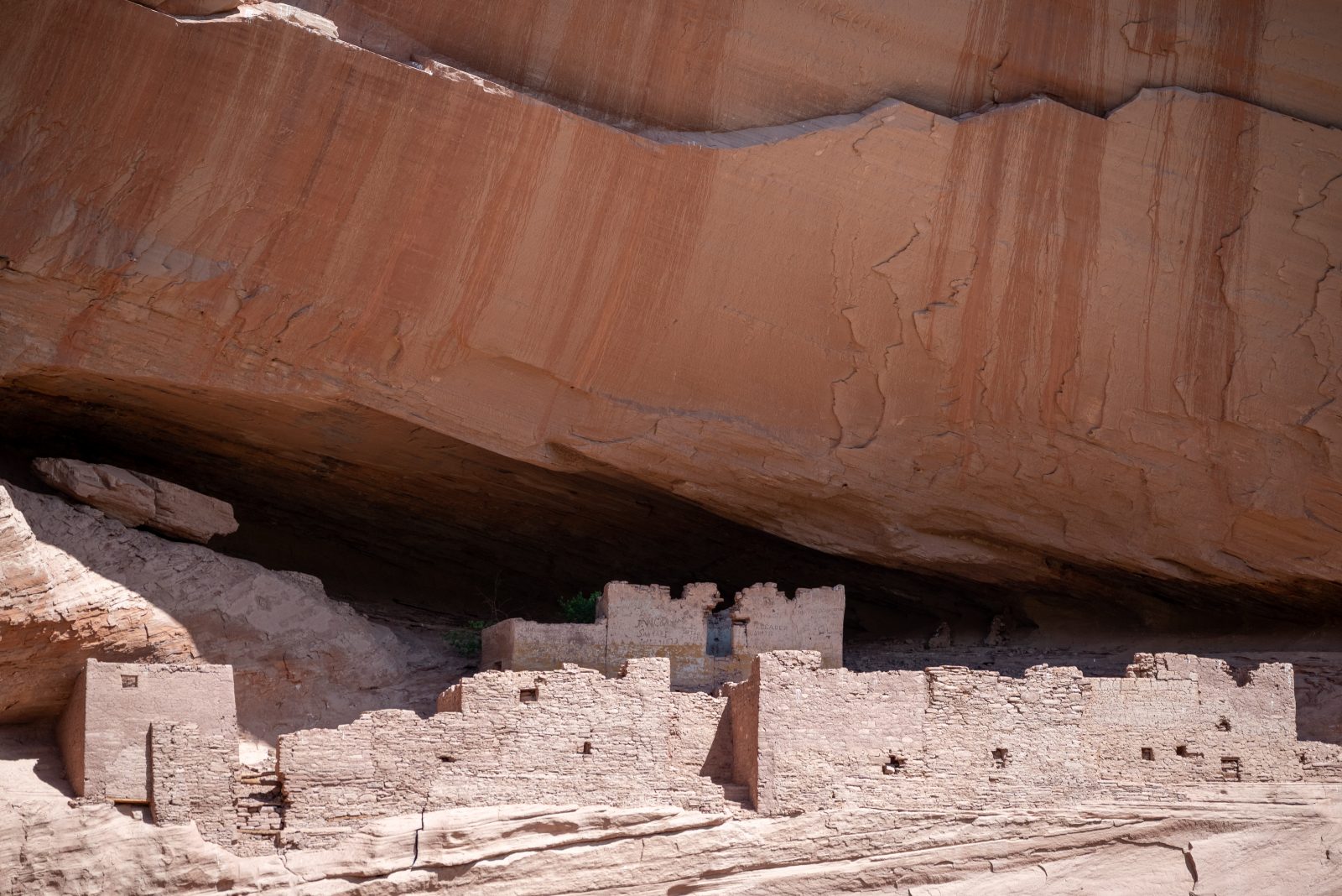
As in Antelope Canyon, tours within the canyon can only be taken with guides authorised by the Navajo Nation, although the monument is run by the NPS (https://www.nps.gov/cach/index.htm). Tours are done in multi-wheel drive vehicles ranging from rugged 4WD SUVs to converted army troop carriers. The canyon has no roads, only tracks and you need these vehicles to negotiate the terrain of wide muddy streams and soft sand. The four-hour private tour we took was organised through the lodge (https://www.thunderbirdlodge.com/tours/). This meant that, rather than the troop carrier being shared with a dozen others, we had it to ourselves. You have a Navajo guide who has an encyclopaedic knowledge of the canyon’s history, geology and natural elements. From the mouth of the canyon the tour wends up the broad riverbed as rock of red-brown shades on both sides transforms quickly from low hills into cliffs that loom 1,000 ft (300 m) above you. The canyon divides. You visit elements of both fork: Canyon del Muerto to the north-east and Canyon de Chelly to the south-east. Trees cluster in the valley floor, interspersed with areas of cultivation, for about ten Navajo families still live and farm within the Monument, doing without mains electricity or running water. Around you are both a fascinating geology in the many rock formations and the sheer scale of the towering cliffs but also a long history told in the petroglyphs on rock walls, in the ruins of the Anasazi villages perched, impossibly, on ledges high above the valley floor and in the words of your guide.

On our trip the skies darken bringing what the people of the region call the monsoon rains; sharp, heavy downpours that can go as quickly as they come. It meant that the thunder reverberating around the canyon created a foreboding atmosphere that mirrored the guide’s description of the lengthy, but ultimately futile, last stand of the Navajo on an almost inaccessible butte against Kit Carson’s soldiers intent on driving the Nation’s people into exile in Bosque Redondo, far to the east. The rain also meant getting wet. The troop carriers have no roof and, although you are offered large ponchos, a return to the lodge meant a welcome change into dry clothes. Make sure you take your own water and any snack you might need.
Mobility Access
I came close to giving this a red designation. It is such a brilliant tour but, for those who have mobility limitations or back issues, you do need to be aware of the potential difficulties. To get into the troop carriers you have to climb up temporary steps to reach the rear of the vehicle where cushioned bench seats (and waist seat belts) await you. The main issue is the sheer bumpiness of the ride. A combination of the uneven ground and climbs in and out of streams mean you receive little respite from the jostling around. There are stops where you can get off to view various sights and to use the one restroom available on the tour.
Rim Drives
This is one activity you can do yourself and at your leisure in your car. Each rim (north and south) is an out-and-return trip. The South Rim Drive is about 36 miles (58 kms) with seven outlooks that can be visited whilst the North Rim Drive is a 26 mile (42 km) round trip with three outlook points. Access to the Monument is free so there are no park fees to pay. And, as well as the spectacular views into the canyons, the sparse, scrubby vegetation and the rock formations of the land along the rims offer a landscape with its own special character.

Mobility Access
Unfortunately the National Park information does not include the level of detail about the accessibility of outlooks that is provided at Bryce Canyon and Zion. And some are pretty inaccessible for those with mobility constraints. Some are close to the road and have short, paved paths and gentle slopes. Others are long scrambles down across bare rock surfaces. I did not keep a careful check on which ones were potentially problematic. Patience and trial and error will still give you some stunning viewpoints to look down into the canyons and take in the American Puebloan (Anasazi) ruins.
On the Road: Canyon de Chelly to Monument Valley
It is only 130 miles (210 kms) between these two iconic places. We took a slightly more meandering route north into Utah to take in two more scenic marvels and an iconic location, all of which are reached off US Route 163 which runs southwest from Bluff back down to Monument Valley, which is just over the Arizonan state border. First up was Valley of the Gods, which has been switched in and out of National Monument status by recent Democratic and Republican administrations. It is now out but still regarded as protected public land. Essentially a 17 mile (27 km) loop road through a landscape known as the miniature Monument Valley, we chickened out of attempting it because signs warn against driving it in wet conditions without 4WD. The recent storms had doused the land with water, filling streams and temporary pools.
Goosenecks State Park
https://stateparks.utah.gov/parks/goosenecks/

Only a few miles down US Route 163, the access to this State Park (fee payable) is down a short (4 mile/6 km) paved road that dead ends at the manned access gate to the large area of ground that sits on the fringe of San Juan River. It is an extraordinarily worthwhile diversion. The view across and down into the canyon as the river curls in two loops around the massive bluffs is simply stunning. In my view a match for the much better-known Horseshoe Bend (see above) with the huge advantages of no crowds (a scattering of other visitors) and easy access for the mobility constrained (the car park is adjacent to the overlooks). Facilities consist of restrooms and a limited number of shaded picnic tables.
Mobility Access
As I say, the overlooks are next to the packed gravel car park. The rock surfaces of the rim are a little uneven but there is a paved area at the walled overlook.
Forrest Gump Point
So called as this is the point, on the deserted tarmac of US Route 163 with the buttes of Monument Valley on the horizon, from which the scene in the movie was shot in which a long-haired, bearded Forrest Gump finally halts his running from coast to coast. Now it is awash with pull-offs and vendor stalls selling local crafts and knick-knacks and demented people taking selfies in the middle of a busy highway (speed limit 65 mph) with traffic bearing down from both directions. The view is still pretty amazing.
Monument Valley
Altitude: 5,500 ft/1,700m. Length of Stay: 3 nights.

Does Monument Valley need any introduction? Just mentioning John Ford/John Wayne westerns conjured up for my generation the iconic buttes of this Navajo Tribal Park (https://navajonationparks.org/navajo-tribal-parks/monument-valley/). Maybe for later filmic generations those movies are part of an unknown history and the Valley is just best known from millions of Instagram photos of the red-rock buttes. It is unmissable if you are on the Colorado Plateau, despite the numbers of us tourists who flood here. The Park is the equivalent of a National Park but administered by the Navajo Nation. It seems remote but there is a small town, Oljato-Monument Valley, which sits around the roundabout on US 163 where you can also find the Navajo Welcome Center. From here one road peels off south to the Valley whilst off in the opposite direction is part of the town and the sprawling resort facilities of Gouldings, where hotel, campground, gas station, supermarket and laundromat provide all the requisites for tourists and locals alike.
Hotel: The View
https://monumentvalleyview.com/
This is the place to stay. This Navajo-run operation sits on a bluff above the Valley and is the location from which so many of those iconic images are taken. Rooms in the hotel all have balconies which look out on that view. The feel of the hotel is definitely of a higher quality than Thunderbird Lodge. Every facility uses that view to full advantage. There is a lovely double-height lobby with floor to ceiling windows facing the Valley. The restaurant which serves breakfast and dinner is shaped to have people fighting for the window tables. Outside on stepped terraces with tables and chairs (but little shade), we camera-and-smartphone-toting folk mill around at dawn, dusk and throughout the day. Alongside is the Trading Post – basically a huge gift shop with a vast range of Navajo, Hopi, Zuni and other American Indian crafts alongside the more mundane clothing, headgear and tourist naffery. It is, inevitably, seriously popular but, unlike the National Park Lodges which can require personal booking, Trailfinders were able to secure ours about six months ahead of time.
Local eating options are very limited, so we ate in the hotel’s restaurant. It is a solid, if unexceptional, menu of American comfort food with a Navajo/Mexican slant. Of course, this means huge portions. It does get busy and tables cannot be reserved, although we never found we had to wait long for a table. They had a smattering of surprisingly toothsome non-alcoholic beers. For lunches there is a bar with wraps and sandwiches, cold and hot drinks.

The room was similar to the standard I describe in Part 1 with unexciting but straightforward décor. Its highlight was the balcony, complete with chairs and tables. From here you can stand or sit and drink in the view from sunrise to sunset. After dark the sky is awash with stars and satellites zip across the sky like shooting stars. And if you turned to your left, you could watch that night’s movie projected on a large blank wall beside the viewing terraces. The movies had only one criterion – they had to include scenes shot in the Valley so, after a break of a few decades, I found myself rewatching Stagecoach.
Mobility Access
A 2008 building with all you would expect, so flat step-free entrances, elevators to the upper floors and a large car park adjacent. Only the terracing outside requires steps to move between levels but, even there, one area is level with the lobby and, a floor up, another is level with the restaurant/bar. There are plentiful seats and tables.
Activities
Private Tour

Unlike at Canyon de Chelly, visitors can drive down into the Valley and follow a 17 mile (27 km) loop track. I hesitate to call it a road as it is packed dirt all the way. To see other parts of the Valley you have to take a tour with a Navajo guide. The hotel has no direct tour booking so I simply looked at the listings on the tours page of the Navajo Tribal Parks website (https://navajonationparks.org/guided-tour-operators/monument-valley-tour-operators/) and ended up booking Monument Valley Safari’s 3½ hour private tour with Don Mose (https://monumentvalleysafari.com/en/private-monument-valley-tour). It may have been expensive, but it was oh, so worth it. Don is in his seventies and dispensed tribal and historical wisdom with a wry sense of humour. We saw landscapes of stunning beauty and not just the well-known buttes but other sights as diverse as awesome wind-eroded rock formations and diminutive tadpoles struggling for life in the shallow puddles left over from the rains. The car was a Chevrolet Suburban, so fully enclosed with comfortable seats, easy access and blissful air conditioning (much needed with daytime temperatures into the mid-80s F/high 20s C). And the surfaces, whilst dirt or sand for the most part, are not as bone-jostling as they were in Canyon de Chelly.
Mobility Access
This tour warranted a green designation because the potential discomforts of driving around on dry dirt tracks in the early autumn heat were more than offset by the comforts of the vehicle and Don’s care in moving us around. There is a little bit of walking on soft sand to get close to one or two sights, but even these can be viewed from slightly further off. Do take care in your tour choice because many group tours use the same sort of open sided vehicles that you might find on some game safaris, which are less easy to get into and less forgiving on limbs and backs.
Walking Wildcat Trail
https://www.visitutah.com/articles/the-wildcat-trail-of-monument-valley

There is only one walking trail in the Tribal Park that can be walked during a day without needing extra permits. This 4 mile (6.5 km) trail drops down from the bluff where the hotel sits and loops across the desert landscape around one of the iconic, much photographed buttes (West Mitten Butte) before heading back up the side of the bluff. Taken before the sun gets too high in the morning you feel you are really escaping the crowds. Folds in the land often hide the hotel from sight and I only saw seven other people during near 2½ hours the walk took me. You can really have a sense of the wide, open lands of the Plateau. A tiny lizard scuttling across the path apart, the only creatures are the birds and swarms of butterfly/moth insects that spread across the path and neighbouring sagebrush. The path is well-marked and the only strenuous bit is slogging up through sections of soft sand on the climb back up to the hotel on the bluff. There is a rudimentary toilet about half-way and, about every kilometre, shaded benches but otherwise you are out in the open with no shade. Go early and go prepared with water, sustenance, hats and sun-cream.
Mobility Access
Realistically no for those with limited walking capacity. Terrain and length count against you here.
