As with other lengthier trips I have broken this piece down into what I hope are manageable chunks. There are five separate parts.
Part 1: Prelude, Practicalities and Other Preliminaries
Part 2: Zion and Bryce Canyon National Parks
Part 3: Lake Powell, Slot Canyons and the Navajo Nation
Part 4: Winslow, Route 66 and Death Valley
Prelude
An unashamed road trip through the scenic wonders of the Colorado Plateau and Death Valley in California. The trip also took in the fascinating Anasazi and Navajo societies that once dominated the region before the smothering tide of white America rolled in from the east. Despite that the Navajos were restored to their lands in the last quarter of the nineteenth century, establishing the largest reservation in the country, now known as the Navajo Nation, and becoming the largest group of American Indians in the country. This added another cultural dimension to the trip.

And the scenery was beyond our expectations. Of course the reputation of the region’s iconic names preceded our trip – the National Parks of Utah’s Grand Staircase and iconic sights of the Navajo Nation have long fed a wish to come to the region. Running in a broad swathe from north-east to south-west in a line across Utah to the northern fringes of Arizona are Arches, Canyonlands, Monument Valley, Capitol Reef, Escalante, Antelope Canyon, Bryce, Zion, and the iconic Grand Canyon. To take them all in would have been beyond the scope of a month-long trip, at least for those, like us, who prefer to take things at our own pace and spend a few days in each place. So we talked to those who had been before. Then we considered our own mobility constraints and the potential effect of scenic overload. Grand Canyon was discarded on the basis of ‘been there done that’. Others, like Arches, require hiking beyond our mobility constraints to reach the dominant sights. The choices we made were Zion and Bryce, conveniently close to each other. Beyond that a long-held enjoyment of Tony Hillerman’s crime novels (with their protagonists from the Navajo Tribal Police) led us to want to mix in the Navajo Nation, which meant we could take in Antelope Canyon, Canyon de Chelly and Monument Valley all of which lie within its boundaries. A teenage engagement with the music of the 1960s and 70s exerted a draw onto Winslow and the Arizona section of Route 66. Add into that Death Valley, the very name of which exerts its own draw.
As a coda to the journey we took our urban fix in Salt Lake City, drawn, in part, by a wish to understand a little about the culture of The Church of Jesus Christ of the Latter Day Saints (more popularly known as the Mormon Church) in the place that is both the spiritual and administrative centre of that faith.
Structure/Itinerary
This was a trip of 33 days that involved flights in and out of Salt Lake City and a circular road trip taking three or four nights in each key location with three one-night transit stops to break the length of the longer journeys. The key locations will be apparent from the headings to the several parts to this blog. We tried to keep the driving distances relatively short allowing us more time to stop and gawk at the scenery and take in places along the road. Nonetheless, with all that stopping and gawking, there were some days of six to ten hours between overnight stops.

Organisationally, I usually envisage booking all aspects of a trip to the United States myself. From previous travels, I know what we are looking for from accommodation, flights and car rental to feel confident in my choices. In this case the wish to be in the National Park lodges (often the only hotel-style accommodation within the relevant National Park), coupled with the fact that such places get booked up as far as a year in advance and are often only bookable direct with the lodge, reinforced this view. However, the spiralling cost of business class flights since the COVID-19 pandemic created some pause for thought. I wondered if there were cheaper options using third party providers. Decades ago I had used Trailfinders for longer flights when they were a ‘bucket shop’ flight provider. Now a worldwide travel company with a dedicated business class service, I discovered their flight only costs were the same as my own researches but, if I booked a hotel or car hire with them, the total cost was almost half the price of just taking the flight. I cannot pretend to understand how this works, but it was a no-brainer and flights and car rental were dealt with. It meant I was still in control of the hotel/lodge bookings. It was only an enforced cancellation and re-organisation of the trip that meant also calling on Trailfinders to help with some of the hotel bookings on that revamped trip. I have tried to make it clear where I booked accommodation direct and where it was done by Trailfinders. Their service was efficient and helpful but lacked the aspect of personal knowledge of the region we would get with our usual travel advisers, Audley.
When and Weather

We had originally planned this trip for the spring of 2025 but had to move it to September. The key in deciding when to visit this part of the world is the weather and that consideration may help guide any choice of places to visit. For example, on the Colorado Plateau the temperature varies considerably with altitude, so the summer temperature in Bryce Canyon can seem balmy, around 26/27°C (79/80°F), yet Zion, barely two hours’ drive away, reaches nearly 37°C (100°F) and if you were thinking of heading to Death Valley at that time, don’t (47°C/117°F). Conversely Death Valley is a civilised temperature through much of the winter months but during that period Bryce Canyon is snowbound and the sites potentially inaccessible. For that reason, I have not given details of the temperatures for the areas we visited but the variations meant having to pack for the differences between the evening chill in Bryce Canyon (around 6°C/43°F) and the afternoon heat in Death Valley (up to 38°C/102°F). Our itinerary meant taking in the higher, cooler locations in early September and finishing the Parks and Monuments section of our trip in Death Valley towards the cooler end of the month. Even then, it was still too hot through the afternoon there for us to be outside the balm of air-conditioning of room or car for too long, although the nights were suitably mild.
So my advice is to spend some time researching average temperatures at the time you want to travel and choose your destinations and itinerary accordingly. There are a number of websites that cover the whole range of weather averages (e.g. temperature, rainfall and humidity are often important to us). I used Weather Spark for this trip – https://weatherspark.com/. The final point to note is that throughout the region the heat is a dry heat. My investigations of average humidity levels in the various National Parks and towns seemed to indicate that 0% humidity was the norm. This does mean the heat is not as sapping as a similar heat would be in India for example.
Reading

Fiction
Leaphorn/Chee Novels by Tony Hillerman (https://ehillerman.unm.edu/publishedworks#sthash.KrLCepTT.dpbs)
I have already mentioned the detective series about the Navajo Tribal Police by Tony Hillerman which, as well as being an entertaining example of the genre, gives insights into Navajo culture, their beliefs and attitudes and into how their world view differs from that of broader American society that surrounds their nation and how the two cultures interact. Hillerman died in 2008 and, since then, his series has been extended by his daughter, Anne Hillerman. I am always slightly wary of continuation series that seem to lack some spark that illuminated the originals. However, I decided to buy the first one whilst in the region and found it an enjoyable read in its own right, as she re-focuses attention more onto the female characters in the original books.
There, There by Tommy Orange (https://www.waterstones.com/book/there-there/tommy-orange/9781784707972)
This is an altogether different proposition. A debut novel from a Native American writer, it was a Pulitzer Prize finalist. Orange is a Cheyenne-Arapaho brought up in Oakland, California. This novel focuses on the realities of life for off-reservation Native Americans living in modern inner-city California and how difficult the life choices can be when they are caught in between the predominant ‘white’ culture and that of the tribes of which they are part. It follows the interweaving lives of a dozen characters, which intersect at a Native American powwow. It is a powerful, gripping narrative whose characters come to life on the page.
Non Fiction
Four Corners: History, Land and People of the Desert Southwest by Kenneth A. Brown (https://www.abebooks.co.uk/9780060927592/Four-Corners-History-Land-People-0060927593/plp)
Although it is now nearly thirty years since this book was written, it is such a good read as an introduction to the area that I have no hesitation in recommending it. It helped us understand the interlinking geology, botany and zoology of the astonishing landscapes that we saw and how those living and working in the region are seeking to protect those landscapes. Because it is interweaved with pieces on the Spanish (ostensible controllers of this land until 1848), the Navajo, the Hopi and the Mormons, it provides an engrossing companion to the region. With apologies to those familiar with the phrase but the Four Corners refers to the region around the notional spot on the earth where the borders of the states of Colorado, New Mexico, Utah and Arizona meet.
Bury My Heart at Wounded Knee by Dee Brown (https://dauntbooks.co.uk/shop/books/bury-my-heart-at-wounded-knee/) and The Earth is Weeping by Peter Cozzens (https://www.waterstones.com/book/the-earth-is-weeping/peter-cozzens/9781786491510)
I had never really engaged with American Indian history. Brought up with the ‘western’ movies from John Wayne and Clint Eastwood, my actual knowledge of the reality was grounded in the ‘wild west’ of stereotype, albeit with a growing awareness from other historical reading of the decimation inflicted over the centuries on those tribes and cultures. These were the two books I read as a corrective. The former, written in 1970, is one you still see on many a bookshelf including our own. Telling the story from the perspective of the American Indian, its main effect was to re-orient the focus of so much earlier history. It remains a shattering read, bringing to the fore the endless string of broken promises made to these peoples as they were ground down by the relentless pressures from politicians and settlers moving ever westward.
Cozzens’ 2017 book seeks to be a balanced history of the so-called ‘Indian Wars” that took place in the west United States from the end of the Civil War through to the events at Wounded Knee in 1890 and it does not shy away from the atrocities committed by all sides. A prize winner for military history, at one level it might seem a rather dry read. I found it anything but, with a cast of fascinating individual characters on both sides. There is a gradual mounting of the horror at the way the powers of the time sought to obliterate or assimilate the Native American groups, with no compunction about setting one group against another to further the demand for land and resources.
Diné: A History of the Navajo by Peter Iverson (https://www.amazon.co.uk/Dine-History-Navajos-Peter-Iverson/dp/082632715X)
This was purchased on our travels (a good bit cheaper than on Amazon) as I wanted to understand better the history and culture of the people whose land we were visiting. The Navajo only settled in these lands from about the thirteenth century, but the book focuses on the period of their early interaction with the westward push of the white Americans, the sorrowful interlude of exile after the bulk of the Navajo were rounded up and force-marched into quasi-captivity in the later part of the nineteenth century and their return (and the establishment of their reservation) before the end of that century. A further section then covers the struggles and development, through the last 125 years, of what was to become the Navajo Nation. This includes their own political infighting as they continue to find a way to govern a people whose culture is centred on self-supportive, family-orientated communities. It is competently rather than elegantly written but gives real insights difficult to find elsewhere.

Delorme Road Maps (https://randpublishing.com/delorme/?srsltid=AfmBOorv5G91HrojDAvNxW4TQb-TlagCzhcXjbF19Dxj9xuEJc8L8ega)
I am going to cheat and repeat what I said in a post I did on driving the Oregon Coast.
‘…in the United States I am a huge fan of the beautifully detailed Delorme atlases of the individual states ever since we used them to navigate our way through a circumnavigation of Lake Michigan over a decade ago.’
How anyone can make the most of the sights and places to see on the road if they just punch ‘Destination’ and ‘Directions’ into their map app I can’t really fathom, but then that is my generational failing.
Guide to Scenic Highways & Byways (https://www.amazon.co.uk/National-Geographic-Scenic-Highways-Byways/)
Pardon me a diversion here to extol the pleasures offered by the US’ network of these scenic roads, which are gathered under the heading America’s Byways. I have already touched on them when writing about the Oregon Coast but, if you are planning any sort of driving holiday in the USA, it is well worth the time to check out those in the area you are visiting. These government designated routes are set out on their rather old-fashioned looking website (see the link covered in Part 2 in the section On the Road: Zion N.P. to Bryce Canyon N.P.). If, like me, you are a maps and paper aficionado, then we have found National Geographic’s guide to be an excellent planning resource.
Practicalities
America The Beautiful Pass
https://store.usgs.gov/2025-annual-pass
If you are planning to visit more than two National Parks on your trip, get one. For the more popular, larger National Parks, the price for a standard pass giving you vehicle access to a single park was $35 (in 2025). That pass is only valid for seven days. This annual pass, which gives full access to all National Parks and many other monuments, costs $80. Even my poor maths can work out this is another no-brainer. Buying it online beforehand is awkward as it seems you have to have the pass posted to your home address. However, you can easily buy one at the entry gate to the first National Park you visit. So we did.
Eating Out and Picnics on the Road
Except in Salt Lake City, we found restaurants served their evening meals early and closed early by European standards, often being done and dusted well before 21.00. The other thing that has to be said is that, with one or two honourable exceptions, the food offer in smaller towns is relentlessly similar, with carbs and fried something to the fore. A sort of relief is offered by pizzas and Mexican-framed cuisine but where‘ere you go the portions will be large (not to say enormous) and vegetable matter, other than occasional salads, is thin on the ground. The ‘to-go’ box is so ubiquitous that I am surprised they are not brought out with your food.

Sadly the supermarkets in the country areas offer little respite and there is rarely an alternative. Yes, there are plentiful fresh fruit and veg, but it is difficult trying to find the sort of lunch salad offer you may be used to in many urban supermarkets. For picnics on the road, we resorted to boxes of cherry tomatoes and packs of nuts and seeds, supplemented by fruit, nut bars and some cheese and meats (all pre-packaged). The choice in cheese in particular seems horribly limited; cheddar, Monterey Jack, Emmental and Swiss cram into enormous cheese cabinets in many types of packaging in slices, grates and slabs. I honestly find it difficult to find much taste of difference between any of them. We did happen upon ‘sharp’ cheddar but, to me, it would just about have qualified as a medium-flavoured cheese in the United Kingdom. Its relationship to say, Montgomery Cheddar, was remote. I make an exception to my ‘grump’ for the Whole Foods supermarket chain whose natural and organic food offer is a cut above the norm. And they, and some other supermarkets to be fair, offer a ‘serve yourself’ hot food and salad bar which meant we could find more variety. However, they only have outlets in the bigger urban centres (Salt Lake City and Flagstaff in our case).
Despite these grumbles, there are many joys to the American cuisines and we ate wonderfully well in Salt Lake City and in some hotels and restaurants on the road. American breakfasts, of the type you order off a menu rather than get offered as a buffet, are a secret pleasure we have always enjoyed. And the Americans do one of our ‘go to’ breakfast foods: oatmeal (porridge to us Limeys). Nearly every hotel had it in the buffet or on the menu.
Time Zone
I was looking at the slight complexities of time zones in the United States and see that I should be referring to time in any particular place as + or – UTC. Unbeknownst to me, what was to my generation of schoolchildren known as Greenwich Mean Time is now Co-ordinated Universal Time or UTC. Like its forebear GMT, UTC is an unchanging baseline so has no seasonal changes. The regions we travelled to had the following time differences from UTC:
• Utah -6 or -7 hours
• Arizona -7 hours
• California -7 or -8 hours
• Navajo Nation -6 or -7 hours
So, in essence a jet-lag inducing six to eight hours behind time in Britain. Like Britain the time changes with the season so Utah, for example, is always seven hours behind London time. Except in Arizona. Because time there never changes with the seasons, you may find it is six hours behind rather than seven. And just to make things awkward the Navajo Nation which lies within four states, but with the bulk of its area within Arizona, follows the same time as Utah. Herein lies a pitfall for the unwary.

On a drive of around twenty miles from the Visitor Centre at Big Water to Antelope Canyon our smartphones seemed permanently confused as time rocked back and forth. We moved from Big Water in Utah (-6) to Page in Arizona (-7) and on to Antelope Canyon in the Navajo Nation (-6 again). There is a practical point here. Staying at a hotel in Page, we had to be at Antelope Canyon at 10.30 for a tour. But was that 10.30 Arizona time or an hour earlier at 10.30 Navajo Nation time? The helpful person at the hotel reception explained that despite being within the Navajo Nation, the tours operated on Arizona time.
Cards and Cash
Thankfully technology and the COVID-19 pandemic seems to have changed the United States from a ‘chip-and-pin’ averse nation into one that has gone the whole hog and adopted the card in the smartphone as the standard means to pay for anything. As it was sometimes possible to add the tip electronically, we found we really only needed cash for tips where that option was not available.
Mobile Coverage
For Europeans, mobile phone use is ruinously expensive if you use most providers’ standard service. Yes, nowadays people use WhatsApp for calls but out here you are in some of the least densely populated parts of the United States. Out on the road Wi-Fi is limited, to say the least. For the most part there is mobile phone coverage, although that too disappears occasionally. So, limping along behind the curve with technology, we finally discovered the eSim. For those unfamiliar with this concept, I am going to leave the explanation to others – https://www.moneysavingexpert.com/mobiles/what-is-an-esim/. Suffice it to say, we bought a month-long eSim package (from Airalo) for about $30 which, given the extensive use we made of it, compared very favourably in price to the daily package offered by our UK providers. We found it pretty straightforward to buy, download and switch on.

Language
Okay this is a slightly tongue-in-cheek entry. Most people are all too familiar with the American English usages, but I still managed to elicit blank looks by unthinkingly using the word ‘petrol’ at gas stations or ‘lift’ in hotel receptions. My only new word was ‘liftgate’. This we discovered when the lock on the boot of our SUV failed and we had to explain the issue to the rental company. In this piece I plan to use American words when they seem appropriate.
Hotel Rooms
I have this as a generic entry because we used a range of hotels on this trip but, despite the variety of rooms, most of them had the same basic facilities and configuration. So I am going to cover that basic bit here and only refer to differences where we came across them. First of all, North American hotel rooms are spacious compared to counterparts in Europe. This is the case across the price range of the places we stayed (largely mid-market) from Holiday Inn Express through National Park Lodges to Sheraton. The everyday offer includes TV, USB sockets, plenty of wardrobe-style hanging and drawer space, a chair or two, a flat surface/desk and a fridge (but with nothing in it, so buy your own water) and, critical in the late summer desert heat, air conditioning that works. The en-suite bathrooms are a decent size with plentiful towels, one or two sinks, the usual basic toiletries, a shower or, more often, one of those tubs with shower over (and shower curtain) that look so low-sided to the European eye. They also suffer from the same want as nearly all hotel rooms we encounter: no hooks for hanging hats and wet coats near the door and no non-slip mat to put in the shower/tub – surely these would be so simple for hotels to provide?

Flights/Arrival
Delta fly direct from London to Salt Lake City and with a flight time of around 10½ hours, we used their business class service. US carriers often get a bad press for their service. As the main way to travel between American centres they suffer from being the equivalent of commuter trains in Europe. All I can say is that, in general, I have found their international business service fine and Delta’s was very much on a par with most other international carriers. They, like so many these days, seem to be skimping on leg/foot space in their lie-flat seats. For a tall person this can make trying to sleep less comfortable than it ought to be but, that apart, it was as pleasant an experience as any long-distance flight can be. And as Salt Lake City is one of their hubs, the lounge is spacious, well-stocked and comfortable. The one slight surprise in this era of America First was that the aircraft Delta used was an Airbus.
We had been warned by recent travellers to the USA that passage through US border security has become a longer, more fraught process with the recent changes made to deter some from entering the country. Also, there had been press reports in the UK of social media accounts being checked on smartphones to see if there were posts critical of government pronouncements with some people being barred from entry as a result. We girded our loins for lengthy delays only to have the speediest transit from plane to arrivals hall I can ever recall on entry into the United States.
Mobility Access
Salt Lake City International Airport shares the same issue as every large airport: those seemingly never-ending distances to and from gates. But like so many equivalents nowadays, it is pretty well set up with mobility assistance, provided you have asked for it in advance. The plane to arrivals hall service included waiting with us for luggage to emerge in the baggage hall. And the distance from arrivals hall to car rental service was short with elevator access within the vast car park.
I have covered the accessibility issues and mobility assistance at London Heathrow Terminal 3 recently, both in the general post on Air Travel from London and that on Three Cities in Finland.
Car Rental and Driving

In this piece I give driving distances first in miles, not my usual kilometres, because that follows what you will find on the ground. Roads are designated by initials. These are, in descending order of scale, I (Interstate dual-carriageway highways), US (US routes that can be both dualled and single lane highways), SR (State Routes that are mostly single lane highways) and NR (Navajo Routes within the Navajo Nation that are single lane tarmac and graded dirt roads). Lesser roads usually live by names rather than designations.
Trailfinders had booked us with Alamo as car rental provider. As with all the other internationally available car rental companies, the service is slick, organised and the cars all work – for the most part. I have mentioned the small difficulty we had with the liftgate lock. In that case, swapping cars at the nearest rental location was the work of barely 15 minutes – once we had got there. We rented a mid-size SUV. We now prefer SUV’s simply because they provide easier access for stiffening bodies than saloons/compacts or, in the USA, those over-sized pick-ups with steps up into the double-cab. I have still not ventured into an electric/hybrid vehicle and, coupled with a concern about range limitations given the distances we were travelling (and availability of charging points), we went gas-powered and automatic. In fact every hotel we stayed at had several charging points, as did most of the gas stations we frequented.
This trip was the first on which we checked in at the rental counter and were told, just go to the line marked Mid-Size SUV and pick a car – the gas tank full and no check of the car made. A choice of cars? How to make it when you are not a car aficionado? All cars seem so well equipped these days and with an inherent reliability that making a choice between makes becomes meaningless to me. So we chose by colour. With hot sunny days a light reflective colour seemed preferable. There is a silver one. It happens to be a Mitsubishi but could equally have been any other make. The keys are inside and off we go. The longest time is spent at the exit barrier, which is where they seem to do the necessary documentation checks.
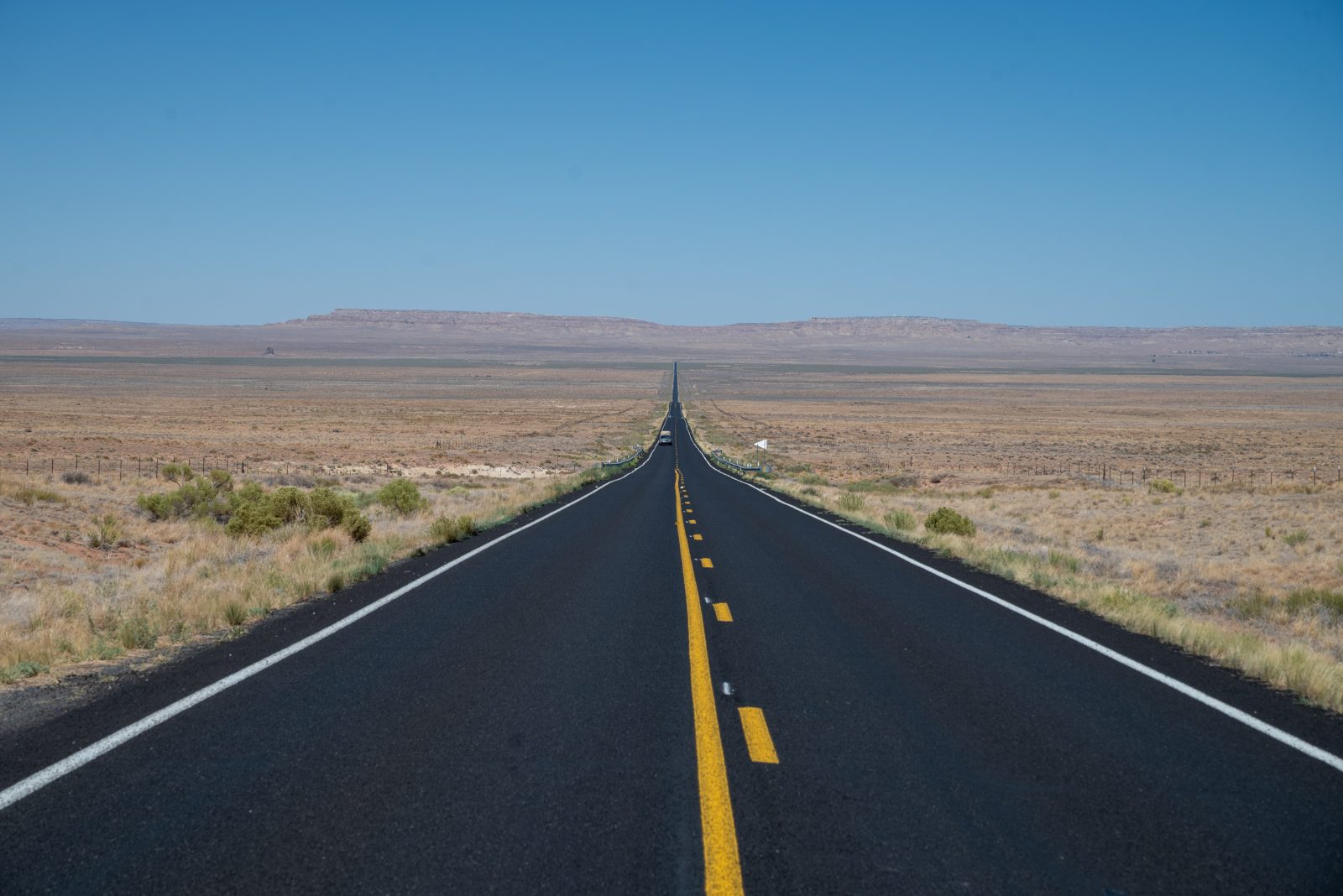
Driving out here is often a breeze. Our big-city urban driving was minimal and outside those places, the roads are often actually empty of any other traffic. As always we avoided driving on multi-lane highways wherever possible. Avoiding the Interstates means you see so much more of the country through which you are travelling and the journey remains part of the enjoyment of the road trip. It also means you are far less often threatened by those monstrous multi-wheeled trucks that seem to get uncomfortably close to your rear before rumbling past. I know this concern is, in some ways, illogical but the images from Steven Spielberg’s directorial debut movie, Duel (https://screenhub.blog/2023/10/11/discovering-steven-spielbergs-very-first-feature-duel-screenhub-entertainment/) are too imprinted on my psyche.

Why are trucks overtaking us in the first place? For some reason memories of US oil-crisis induced speed limits of 55mph seem to have taken a hold on the British mind. Not so any longer. The top speed limit in Arizona is 75mph and that in Utah 80mph and, whatever the limit, the average driver seems to regard an additional 10mph on top as allowable. With our cruise control set at the speed limit, we were regularly overtaken.
Given the distances involved we were cautious about keeping our gas tank topped up. In fact the longest distances between gas stations, even on ‘America’s Loneliest Road’ (https://travelnevada.com/road-trips/loneliest-road-in-america/), were about 100 miles (160 kms). Your gas station is your fuel stop in more ways than one when you are travelling the highways and back roads of these states. It is often the only place for miles in any direction where you can find toilets and buy coffee, water and food supplies, even if the choice is somewhat limited. They may even be the hub of a small rural community – a vast modern Shell station in Arizona was part restaurant, part grocery store, part meeting place and part laundromat. The pumps have credit card screens these days, although I sometimes found they were not always keen on non-US based cards. In that case, using the card at the cash desk was the simple alternative.
Laundromats

Ah, laundromats! Our use of these places to do our holiday laundering is, no doubt, weird to some. However, we have always found they give us an engaging and unusual insight into the local life of a region. For instance, the lack of water and the relative material poverty of the Navajo Nation means that the laundromats are a key service there. On this trip they were much the largest we had ever patronised with rows of different-sized washers or dryers being fed by locals from bags full of jeans and other clothes, colourful blankets, trainers and smalls. Some have attendants dispensing help, change, powder and snacks; others just have powder and coin dispensing machines or a nearby store where, as we did, you can buy your own powder. Machines operate either by using cash or cards and, if cash, there is always a means to get the necessary change. Even in the traveller’s hotels of this region, there is often an in-house laundry room for use by guests which is a smaller version of those in the towns. Go and see a slice of local life and use your waiting time to wander around and take in how life is lived in the smaller communities of the Colorado Plateau.

Ah, another aficionado of the old Westerns, the iconic music I can hear in my mind’s eye when I see your photographs. Lonely wind, tumbleweed.
Wounded Knee was on my bookshelf for years too, as with most of us would-be proto-Americans in the Hippie years, along with the Book of the Hopi which I remember as having beautiful illustrations. Again, thanks for the trip along memory lane (surely the future will have some delights in store too; it’s just that the road back is littered with such entertaining intentions…)